
By Dale Wayne Slusser 10/05/23
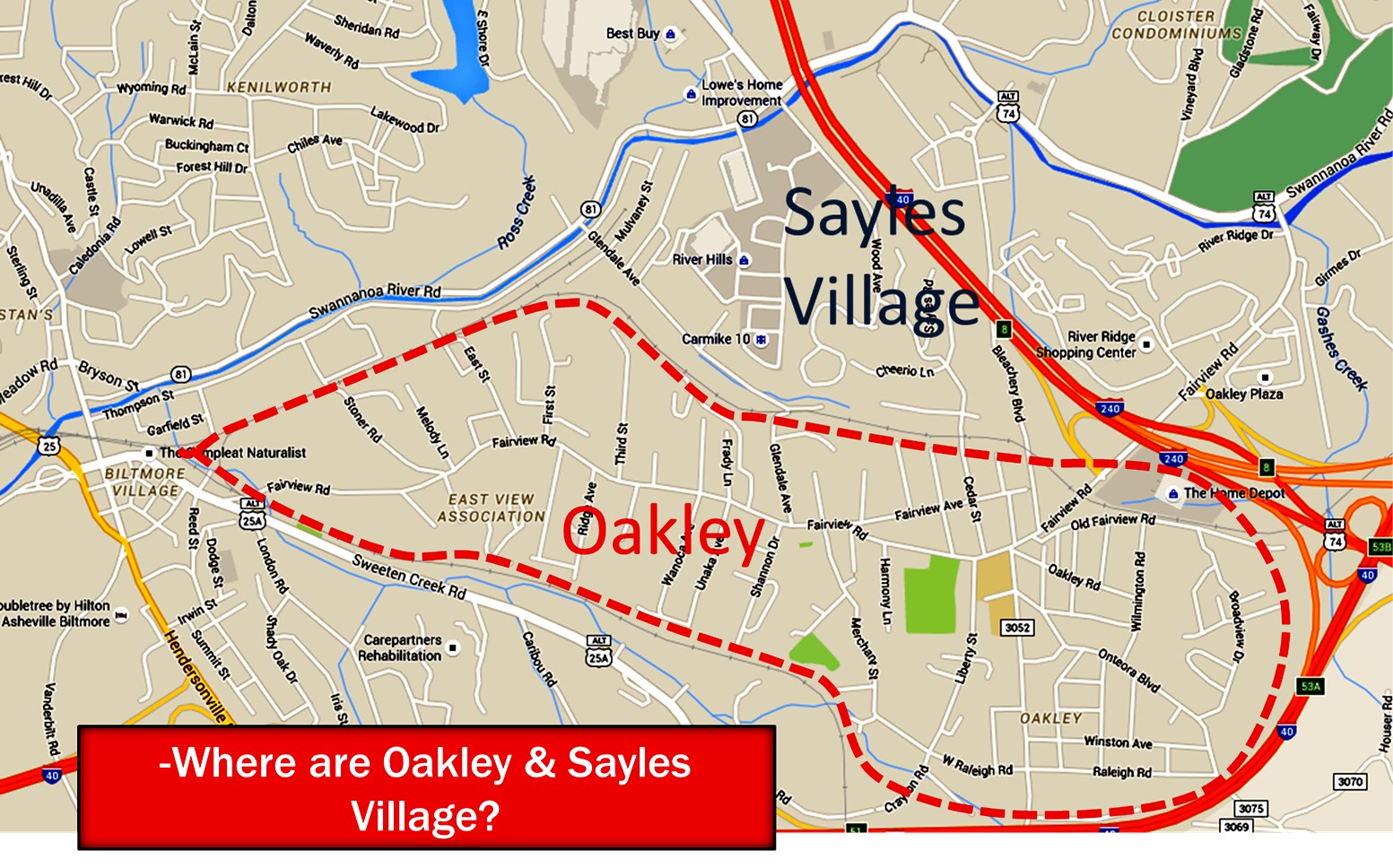
Southeast of downtown Asheville lies the community of Oakley, historically, a working-class neighborhood. Often thought of as a planned community built in 1926 to accommodate the workers needed for the new Sayles Bleachery, in fact, Oakley is an amalgam of small developments that were built along both sides of Fairview Road, beginning in the 1890’s. The “development” of Oakley, is the key to its history, and it is a story of the early suburban development of Asheville.
What is considered “Oakley”? Where are its boundaries? From a 1940’s map of the “Oakley” voting district and other sources, we can say that “Oakley” is the area along both sides of Fairview Road from Biltmore Village, to about the junction of the Charlotte Highway US 74, bordered on the north and south by the railroads. In the early 20th century this area was also called East Biltmore.
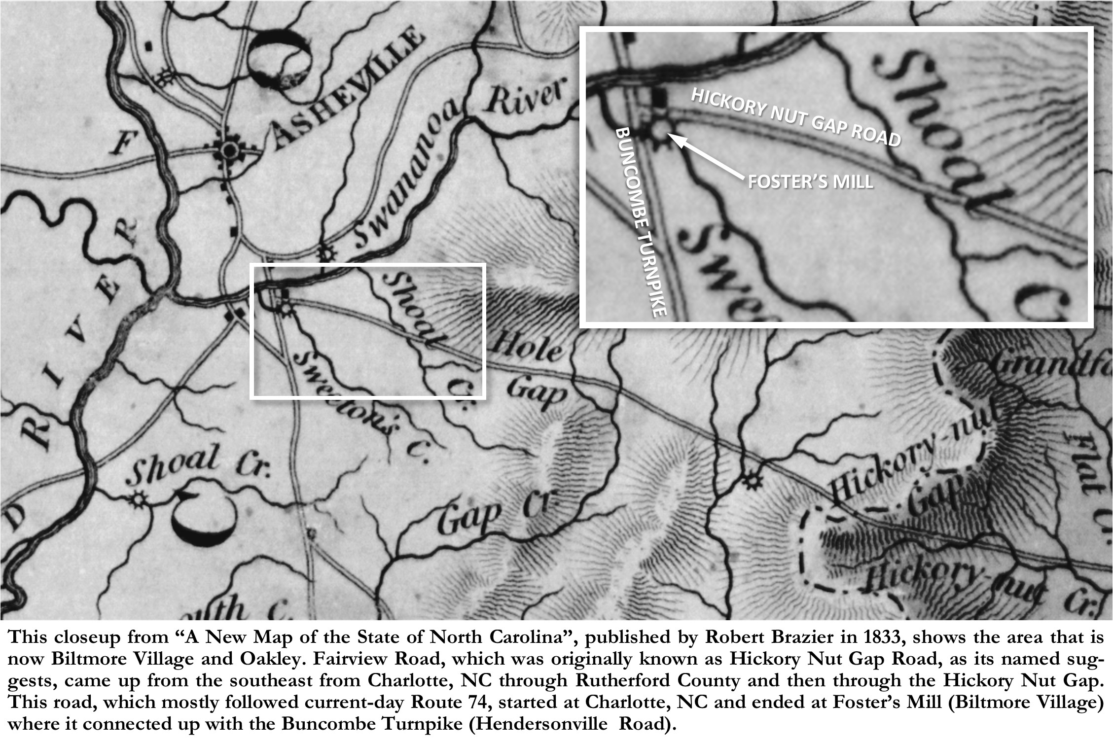
Any discussion of the development of Oakley must include a look at what preceded Oakley. Like most early towns and villages, suburbs often started and grew along major travel routes. So it was with Oakley, which grew up along Fairview Road. In the early days of the formation of Asheville and Buncombe County (1790’s to the 1880’s), before the railroads, Asheville was only accessible by roads that necessarily had to made through gaps in the mountains. Fairview Road, was originally known as Hickory Nut Gap Road, and as its name suggests, it came up from the southeast from Charlotte, NC through the Hickory Nut Gap. This road, which mostly followed current-day Route 74, started at Charlotte heading northwest where it first passed through Shelby and Rutherfordton before entering the valley of the Broad River, also known as Hickory Nut Gorge. The road then followed the Broad River up through the gorge, going through the current communities of Lake Lure, Chimney Rock, Bat Cave and Gerton, before ascending the mountain 1,800 feet, through a series of switchbacks, through the gap to Fairview, NC, and then up the Charlotte Highway, to Fairview Road. Before Biltmore Village (started in the 1890’s) the Hickory Nut Gap Road (Fairview Road) connected directly to the Buncombe Turnpike (Hendersonville Road), just south of the Swannanoa River. Both roads, and their intersection came through the middle of Thomas Foster’s farm (present-day Biltmore Village). Consequently, Foster took advantage of his strategic location by establishing what would become known as “one of the best Stands in the upcountry”.[i] “Stands” were set up, every eight to ten miles along the Buncombe Turnpike, so that the farmers (the drovers) who herded the animals could stop to feed their livestock and get a little rest for themselves, along their journey. Of course, drovers would also use the Hickory Nut Gap Road as well as the Turnpike.
Besides his “stand” where the farmers/drovers and their animals were fed and bedded, Thomas Foster took it a step further, and built a “grist and saw” mill where he could then sell the corn and grain back to the farmers and drovers in the form of ground corn meal and flour. Foster built his Mill on the northeast side of Sweeten Creek, in a small triangle of land near where the Hickory Nut Gap Road connected with the Buncombe Turnpike-certainly a very strategic location. Modern-day readers would recognize the Mill site as the current location of the French Broad River Brewery, on the southside of Fairview Road where the road crosses the creek and railroad tracks. The mill was operated by a waterwheel, with water supplied from a millpond and mill race which came off Sweeten Creek on its northside) further south of the mill, paralleling the current Sweeten Creek Road. Foster Farm clearly shows on an early map titled “A New Map of the State of North Carolina” which was surveyed and drawn by Robert H. B. Brazier in 1833. The map also clearly shows the intersection of the numerous trade routes that converged on Thomas Foster’s Plantation. The map also shows the locations of Foster’s house and Mill.
Thomas Foster died on December 24, 1858, at the age of eighty-four. In his 1847 will, Thomas left the “house, out buildings, and mills” and a portion of his lands to Orra, but since she predeceased him, his executors decided to auction off the entire 700-acre farm, including the house, mills, and other outbuildings on August 25, 1859. It was reported that James C. Davidson was the purchaser. However, I believe that he may have defaulted on his purchase, as the property was put up for sale again by the executor, George C. Alexander, in 1862. At that sale, John Woods Woodfin purchased the property.
Woodfin died the following year (1863) while in battle during the Civil War. His wife Mira retained her life estate of the property, but did not continue to live there, instead she leased the property, “Land and Mills”[ii] to Dr. John A. McDowell. But then in 1868, Woodfin’s brother and executor, Nicholas W. Woodfin, sold the property to Samuel Whedbee. But just a few years later, in 1872 the property was purchased from the Whedbee estate by 45-year-old Joseph Reed, a local blacksmith and entrepreneur from Fairview. Reed, like Foster, would maximize the property’s strategic location at the merging of two major trade routes, and would even see the merging of a third route from the east (the railroad).
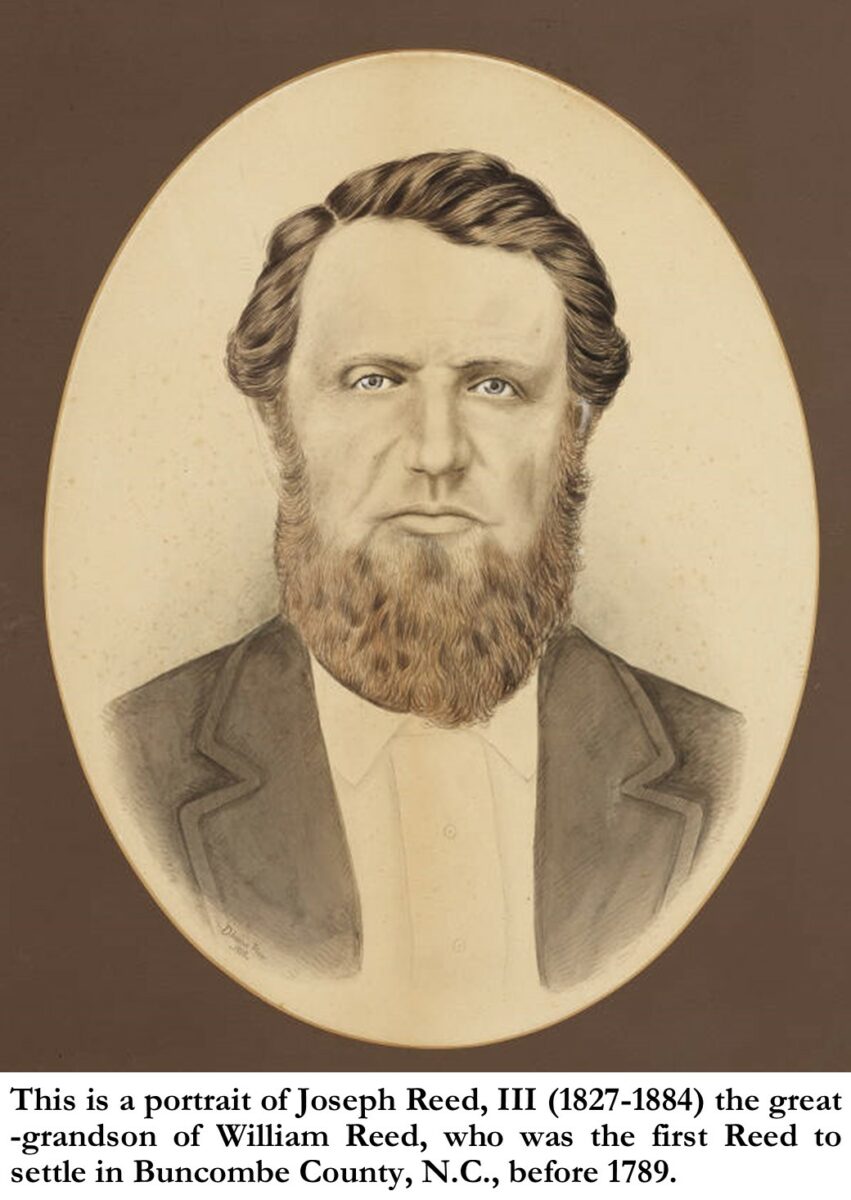
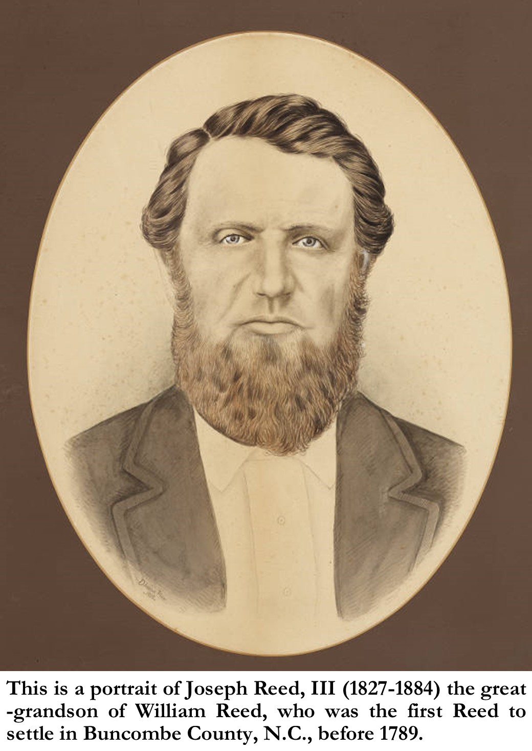
Joseph Reed (1827-1884) was the great-grandson of William Reed, the first Reed to settle in what is now Buncombe County, N.C., before 1789. In 1848, Reed married Catherine Harrison Miller Reed, a descendant of the Harrison family of Virginia, which produced two United States Presidents: William Henry Harrison and Benjamin Harrison. Beginning in 1869, Reed began expanding his land holdings. He soon owned large tracts of land in Buncombe County. In 1871, he sold some of his accumulated land in Cane Creek (Gap Creek) and Gashes Creek and purchased a house on Main Street in Asheville,[iii] where he opened a store, “Jos. Reed & Sons”. And then in 1872, he purchased the “old Capt. Foster’s place”, a 640-acre farm, two miles south of Asheville, across the iron bridge on the south-side of the Swannanoa River (modern-day Biltmore Village and Fairview Road).[iv]
Author and Reed descendent, C. Bruce Whitaker, writes that “Joseph Reed tore Thomas Foster’s house down and built a new house for himself.”[v] Joseph and his family probably lived in the Foster house while building their new house right next door, then demolished the old Foster house after completion of the new home. The property already had an operating grist and sawmill, however, perhaps hoping to pick up business from the many travelers, Reed opened an additional (besides the one in Asheville) general merchandise store along the Turnpike. Soon an array of other buildings began to grow around the store, forming the nucleus of a village. The area began to be called “Swannanoa Bridge”. By the late 1870’s it became evident that Reed’s property would soon become even more strategic. In 1880, the railroads arrived, the W.N.C. RR from the east and the Spartanburg RR from the south, and not only did both railroads cross through the Reed Farm, but they also converged on his farm. Fortunately for Reed (who promoted the building of the railroads) the Western North Carolina RR established a depot at his farm. The depot and Reed’s farm was named “Best, NC” after William Best, the owner of the Western North Carolina RR. Joseph Reed, ever the businessman, capitalized on his good fortune by building a hotel near the depot.
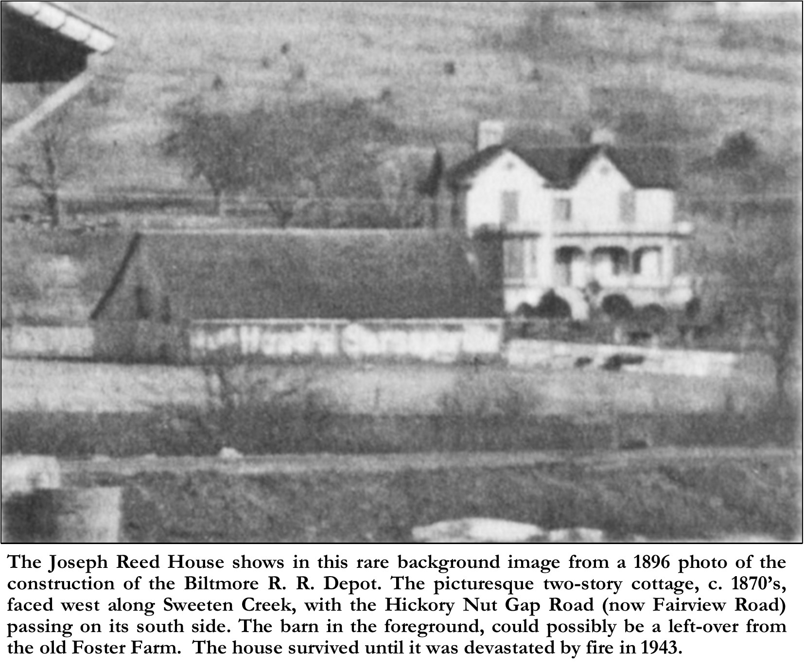
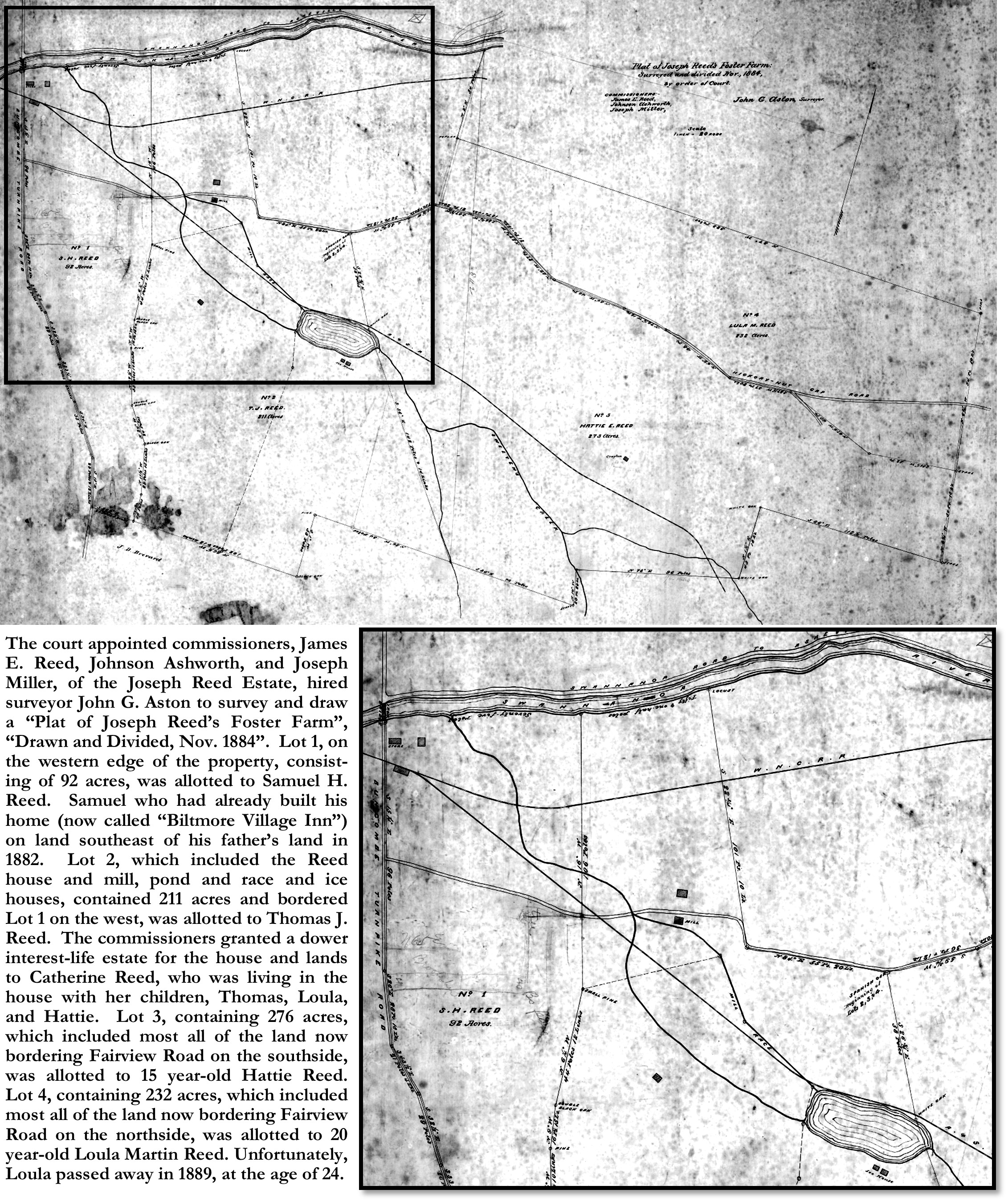
Joseph Reed died intestate on August 22, 1884. In October of 1884, Catherine and their surviving children, Samuel Harrison Reed (1851-1905), Marcus Lafayette Reed (1853-1938), Thomas Jefferson Reed (1860-1903), Loula Martin Reed (1864-1889) and Harriet Katherine Reed (1869-1967), petitioned the Court for an equitable division of the estate.[vi]The commissioners, James E. Reed, Johnson Ashworth, and Joseph Miller appointed by the court, hired surveyor John G. Aston to survey and draw a “Plat of Joseph Reed’s Foster Farm”, “Drawn and Divided, Nov. 1884”.[vii] Lot 1, on the extreme western edge of the property, consisting of 92 acres, was allotted to Samuel H. Reed. Samuel had already built his home (now called “Biltmore Village Inn”) on land southeast of his father’s land in 1882. He sold his lot to Charles McNamee, agent of George Vanderbilt, four years later in 1888. The lot was eventually cleared to become the site of Biltmore Village. Lot 2, which included the Reed house and mill, and contained 211 acres and bordered Lot 1 on the west, was allotted to Thomas J. Reed. The commissioners granted a dower interest and life estate for the house and lands to Catherine Reed, who was living in the house with her children, Thomas, Loula, and Hattie. Lot 3, containing 276 acres, which included most all of the land now bordering Fairview Road on the southside, was allotted to 15-year-old Hattie Reed. Lot 4, containing 232 acres, which included most all the land now bordering Fairview Road on the northside, was allotted to 20-year-old Loula Martin Reed. Unfortunately, Loula passed away just four years later, in 1889, at the early age of twenty-four. In 1891, a substantial portion of Loula’s inherited land was purchased from the remaining Reed heirs by Otis Miller.
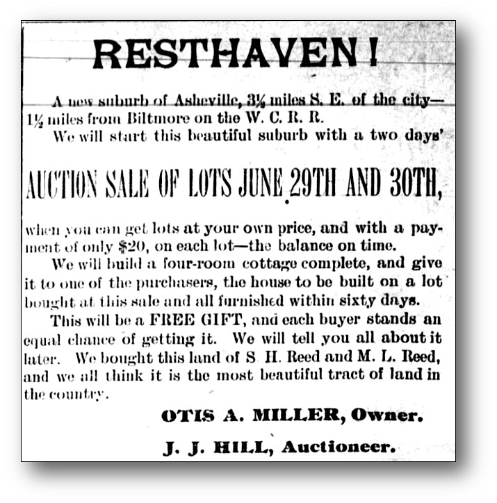
Otis A. Miller purchased two tracts (total 214 acres) from Samuel H. & Marcus L. Reed, sons and heirs of Joseph Reed, along the north side of Fairview Road, for a new subdivision to be named, “Resthaven”.[viii] This was the start of the eventual development of the land along Fairview Road, which by the 1920’s would become known as “Oakley”. An auction was announced for June 29th and 30th of 1892 to sell the lots in “Resthaven”. As an incentive to encourage buyers, each person who would purchase a lot would be eligible for the raffle, the prize awarded would be a free four-room, fully furnished house, to be built on the lot they would purchase. The published advertisement boasted that “each buyer stands an equal chance of getting it”. However, despite all the hype, the auction must have been a failure, as Otis continued to desperately advertise the property throughout the remainder of 1892. But alas there is no evidence of any resultant property transfers, and in 1893 Miller sold both tracts back to the Reed brothers from whom he had purchased them. Although Miller’s development was a flop, the name “Resthaven” remained for a number of years, and in fact an official post office, with Thomas J. Brookshire as postmaster, was established in 1892 and operated until its closure in 1904. From a 1903 map we see that the post office apparently was on the south side of Fairview Road near the site of the Oakley School, or perhaps a bit further east on what is now “Old Fairview Road” near the Home Depot.
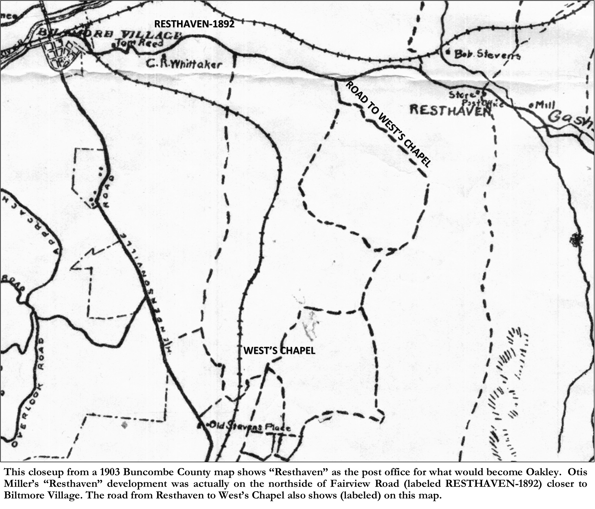
During the 1890’s, as Asheville and its “suburbs” began to expand, the city and county school system sought to keep up with the increased population. To serve the areas of Biltmore and East Biltmore, (Asheville Township) the county school board, had set up three schools, one just south of Biltmore Village, aptly named Biltmore School, also Gashes Creek School (near Gashes Creek Baptist Church), and West’s Chapel School, near West’s Chapel Methodist Church and cemetery (now the northeast corner of the intersection of Sweeten Creek Road and West Chapel Road). West Chapel, was described in 1897 as “about two miles and a half south of Biltmore [Village]”. [ix] The Gashes Creek School appears to have been just over three miles east of Biltmore Village.
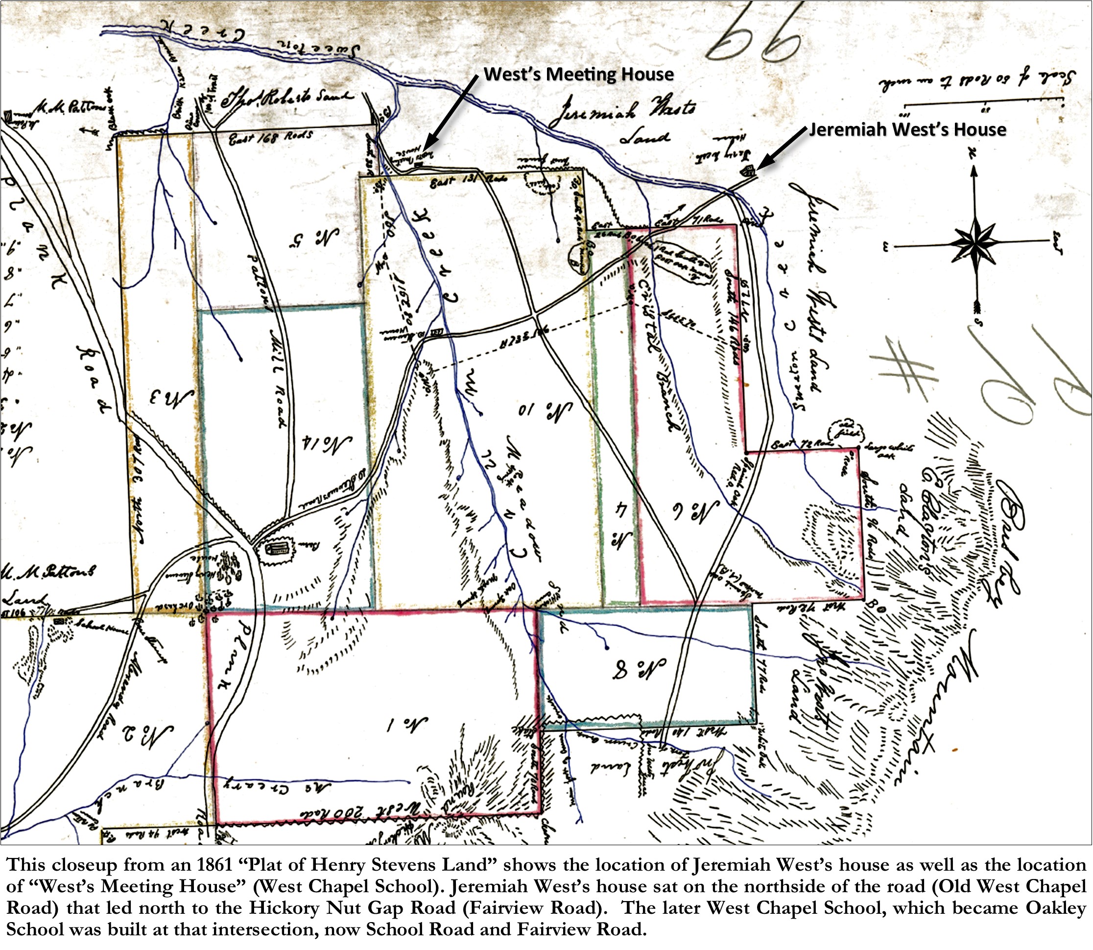
“West Chapel” was established in 1840 when Jeremiah West, a landowner in the Sweeten Creek and Busbee Mountain area (just south of Resthaven), officially deeded land for a “meeting house” and school to a group of trustees.[x] The location of this meeting house/school shows on an 1861 “Plat of Henry Stevens Land”. Henry Stevens was one of the original trustees of the West Chapel meeting house/ school. The meeting house/ school was located on Jeremiah West’s property on the boundary of the Stevens land, which is why it shows on the plat. Remember that the modern “Sweeten Creek Road” was not yet built and so West Chapel was then accessed either from the Buncombe Turnpike (Hendersonville Road) to the west, or from Hickory Nut Gap Road (Fairview Road) from the north. Although the original meeting house/school is long gone, its accompanying churchyard, called West Chapel Cemetery remains on West Chapel Road just off Sweeten Creek Road.
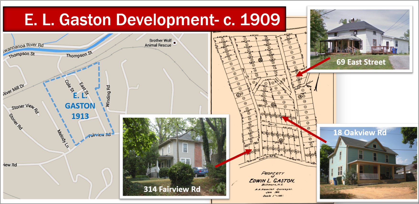
In 1909, E. L. Gaston purchased the western portion of the failed Resthaven development from the Reed family and platted out a small development.[xi] Gaston’s development did not take off immediately. The first lot sale was not until 1913 and the next sale was not until 1916 and even then, he only had two sales in 1916, and six in 1917. Most of the lots eventually sold between 1920 and 1926. Gaston’s development set a precedence for the future development of Oakley in that his lots were small, and his houses were modest, appealing to those of modest means from the working or middle classes. Three examples of houses built in his development- 69 East Street; 18 Oakview Rd; and 314 Fairview Rd, illustrate this point. The house at 314 Fairview Road, which was built by Biltmore Village store owner T. L. Trantham was on a larger parcel (he had purchased an entire “Block” of lots), but he built a modest simple farmhouse on his large lot.
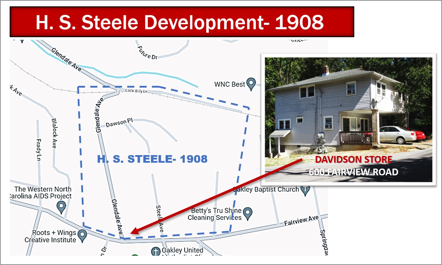
Two other early developments were the H. L. Steele development and the E. W. Patton development. In 1908 Herbert L. Steele purchased a large tract of the former Resthaven development from the Reed family heirs on the north side of Fairview Road.[xii] The tract included land from the west side of Glendale Avenue east to about Pinecrest Rd. Steele’s development was platted that same year (1908), however his first lot sale was not until 1911, when he sold Lots 10 & 11 of Block 1 to A. T. Davidson and his wife. The Davidson’s purchased what is now the property on the northwest corner of the intersection of Glendale & Fairview Road (600 Fairview Road). On their lot they built a store with their residence on the second floor above the store. Although several of the lots along both sides of Glendale Avenue were developed, the bulk of the land remained in the ownership of the Steele family. Even to today some of the land is still owned by Steele’s descendants.
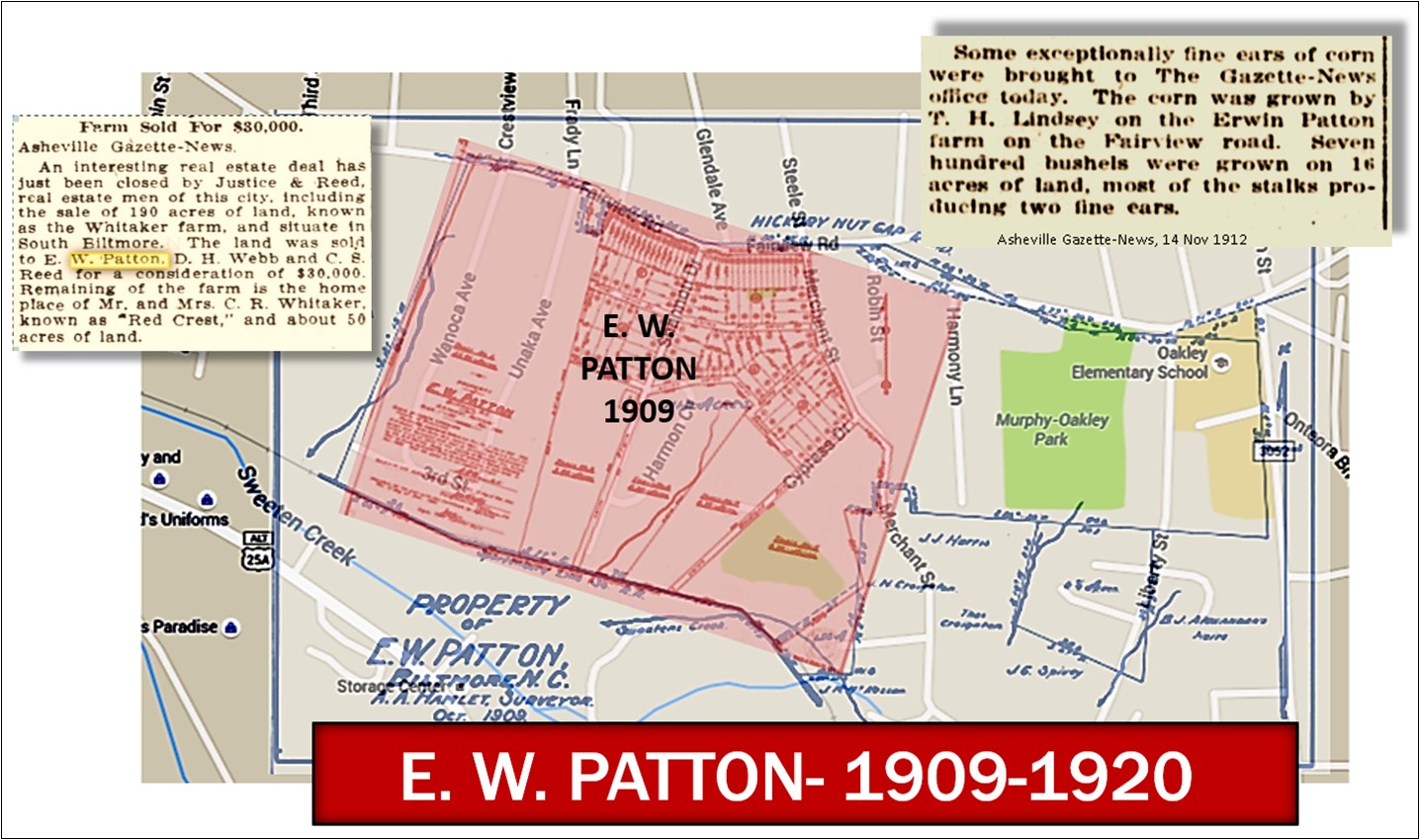
Erwin W. Patton purchased 110 acres on the south side of Fairview Road from the Reed heirs in 1909.[xiii] I believe that he purchased the land for investment purposes, no doubt for eventual development, as he also owned a farm on the north side of the Swannanoa River, where is now the Kenilworth Lake. However, although Patton sold off a number of chunks of the property in subsequent years, he mostly farmed the land until 1920, when he then had the property platted.[xiv] Patton’s development centered on “Erwin Avenue” (now called Shannon Avenue and included land on both sides of Woodlawn Avenue. The land on the south side of Woodlawn Avenue has since been developed into the Woodlawn Cemetery. Unfortunately, that same year, 1920, Patton suddenly passed away, leaving most of the development in the hands of his widow, Ellen Akers Patton. Ellen Patton developed several lots along Fairview Road as commercial lots, in fact, for a number of them she held the titles to the properties and leased them to commercial tenants.
Another early developer of Oakley was carpenter “J. L. Murphy”. Joseph Lafayette Murphy was born in Rutherford County, NC on March 27, 1867, to James W. Murphy and his wife Elizabeth. He married Hester Eva Nesbitt of McDowell County in 1895. “About six years ago”, reported a 1912 newspaper article, “J. L. Murphy, a carpenter, came to Asheville from McDowell County and he arrived with only $65 in money, out of which he paid for transportation of his family and household goods.”[xv] The family first purchased property in Montford on Courtland Avenue in 1905,[xvi] and J. L. Murphy first began work in Asheville as a carpenter with builder/contractor J. C. McPherson.[xvii] But by 1912, it was reported, Murphy had “worked at his trade at wages ranging from $2.50 to $3 a day”[xviii] and had also “recognized the value of real estate, and has bought several lots, built on them, sold them and built again”[xix]. Murphy had become so successful and prosperous, that he was able to afford to begin “wintering” in Sarasota, Florida.
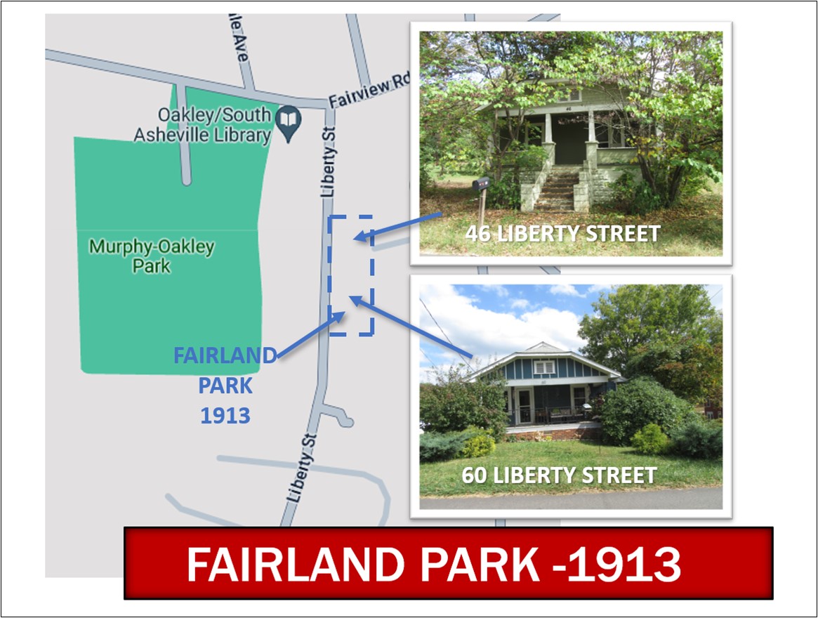
However, despite his prosperity, or perhaps because of it, in 1912, J. L. Murphy and his family sold their Courtland Avenue property and purchased two tracts of land along Hickory Nut Gap Road (Fairview Road)[xx], just west of and adjacent to the Oakley School tract. The two tracts of land which Murphy purchased were a portion of the eastern part of the E. W. Patton farm. Besides becoming a farmer, Murphy also became a grocer, opening a small grocery store on the west side of his new property. The following year, 1913, Murphy began his first development, on the east side of his property adjacent to the school tract. He divided out four lots for a small development he named “Fairland Park”. The plat of the new development was made, but it was never registered/recorded. “Lot 3”, was the first lot sold in Fairland Park, in September of 1913. It was bought by carpenter, Thomas Russel Reed, and his wife Ida.[xxi] Although we know that Murphy provided the financing, it is unclear if he built the house as a spec house or whether carpenter Reed built his own house. In 1915, Murphy sold “Lot 1” to David J. Quinn.[xxii] In 1916, Murphy sold the final two lots- “Lot 2” was sold to W. W. Quinn[xxiii] in January and “Lot 4” was sold to H. M. Cauble in February.[xxiv] However, A few months later, still in 1916, W. W. Quinn and H. M. Cauble sold their respective lots to Thomas R. Reed. The only houses that are still standing in Fairland Park today are the houses on Lot 1 (60 Liberty Street) and Lot 3 (46 Liberty Street), which are similar if not identical to each other.
As these early developments were bringing new families into the area, the two local schools at West Chapel and Gashes Creek could not keep up with the new influx of children. So, in February of 1910, the Buncombe County Board of Education announced that “Superintendent Reynolds [A. C. Reynolds] and Mr. Clyde Reed were requested to purchase a suitable lot for a school building at West’s Chapel in the Gashes Creek district.”[xxv] This was followed in July of 1910 with an announcement that the Board had enlarged the West Chapel district and has “ordered a special tax vote for the purpose of building a school house”.[xxvi] The original West Chapel school, as mentioned earlier, was originally affiliated with the West Chapel church which was south of present day Oakley on West Chapel road near Sweeten Creek Road. In October of 1910 the Board of Education purchased a 6-acre parcel along Hickory Nut Gap Road (Fairview Road) from E. W. Patton.[xxvii] Only 4 days later it was announced that a contract for $1253.48 had been awarded to P. L. Wilson, for the construction of a “two-room building”.[xxviii] The two-room frame building, which shows in a 1917 photo, occupied the lot on the corner of present-day School Road and Fairview Road, where is now the new Gymnasium of the Oakley Elementary School.
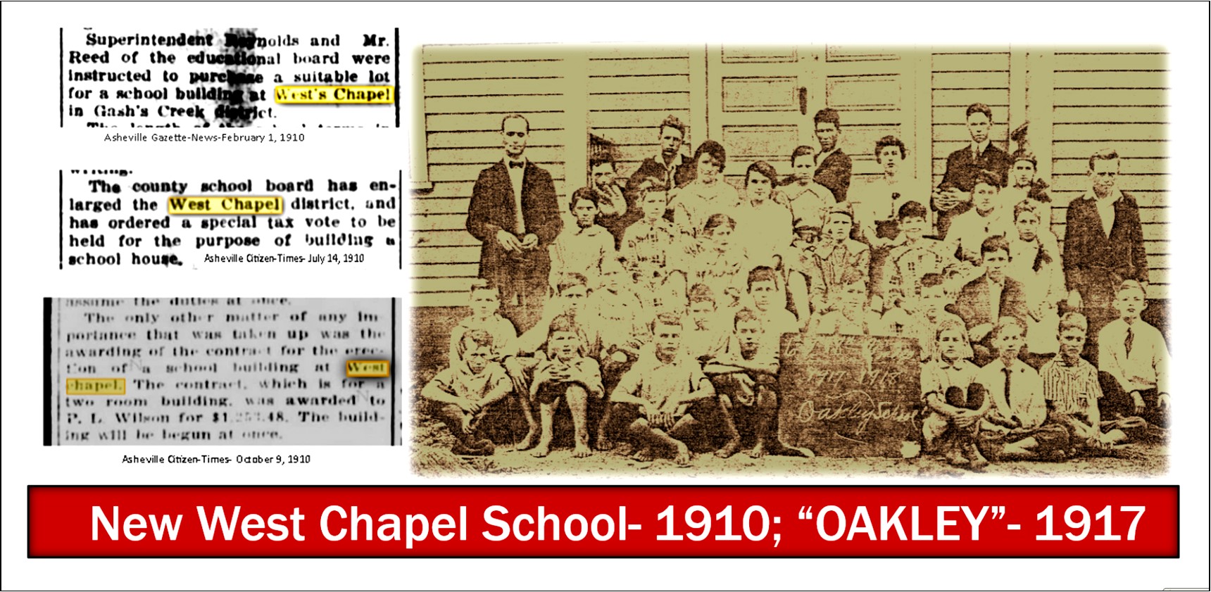
Speaking of Oakley Elementary School-the answer to the burning question of the day- Where did the name Oakley come from? – lies on this very spot. In the aforementioned 1917 photo of Professor Kimsey and the school children sitting in front of the West Chapel School, we notice that on the sign board in front of the students is written, “Oakley School- 1917-1918”. The story as chronicled by former Oakley teacher, Elizabeth H. Redmond, who was an eye witness to the event, says that “Mr. Kimsey [E. B. Kimsey-principal in 1917] announced that the name “Oakley be given to the school because of the many great oaks that covered the area”.[xxix] And so gradually the area surrounding the school assumed the same name of “Oakley”. This story is verified by a 1917 article titled “Closing Exercises at Oakley School”, where the school is called by its new and former names, “Oakley (West Chapel)”. Incidentally, this is the earliest published use of the name “Oakley” for this community that we have found.
The arrival of the railroad in 1880, and the purposeful promotion by city leaders of Asheville as a health resort for the rich and famous attracted moneyed out-of-town capitalists and industrialists into the area. By the early 1920’s it was evident that the city needed a plan for growth. So, in 1922, city leaders hired Landscape Planner John Nolen to draw up a plan for “planned growth”. Although Oakley was slightly outside of the city limits and was not directly part of the plan, it still benefited from Nolen’s recommendations. Not only did Nolen call for the developments of large suburbs outside of the city, along the lands opened up “between the railroads”, now accessible by the “motor car”, but he also proclaimed that in these suburbs, “that the most spectacular development of new building should take place.”[xxx] This statement was immediately followed in the plan by a call for zoning in neighborhoods for “local store centers” to service the surrounding neighborhoods. These recommendations seemed to have impacted the development of Oakley in the 1920’s. Another promotional booklet, called “Live and Invest in the Land of the Sky”[xxxi] published by Asheville in the 1920’s shows on one of its maps, two Oakley developments, “Linwood Park” and “Oaklyn”, interestingly next to a sketch of a “motorcar”-obviously denoting these as suburbs easily accessible by motorcar.

By 1919 the Oakley area, also then known as “East Biltmore” was organizing itself into a community. A group of local residents banded together to form the East Biltmore Water Company, “to operate a community waterline to East Biltmore, along Fairview Road”.[xxxii] This was just in the nick of time as the greatest and most intense development of Oakley began in earnest in 1920. As mentioned earlier, E. W. Patton began development of his farm along Fairview Road in 1920. The Reed heirs, including daughter Lula Reed McCall and her husband C. M. McCall began development of the eastern section of the former Resthaven property in 1920. This “Reed & McCall” development included lands north of Fairview Road, including Cedar Street and Fairview Avenue.[xxxiii] In 1922, L. B. Jackson began development of “Linwood Park” in 1922. More on that later in the presentation. J. L. Murphy platted “Oakley Park” in 1924.
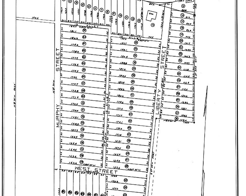
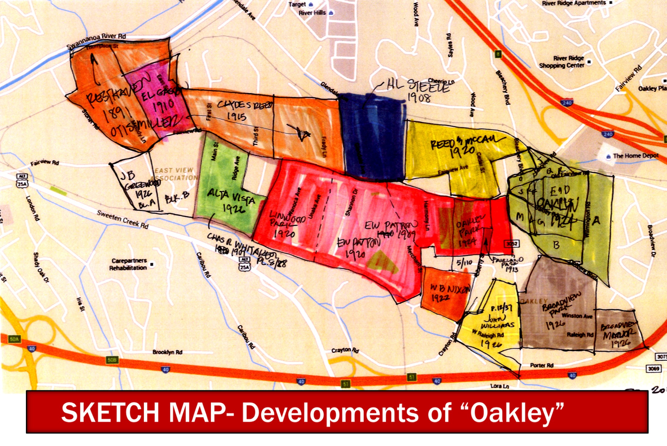
Although we will not discuss all the developments that combined to make up current-day Oakley, here is a sketch map which I compiled showing all the developments, mostly from the 1920’s, that formed what we know today as Oakley. Note that only one has the name Oakley in it, and it was “Oakley Park,” as mentioned earlier, which was developed by J. L. Murphy in 1924. Interestingly although the name “park” at that time designated a parcel of house lots,” today Oakley Park development is a park in the sense of a “recreational park”. The Oakley Library, Community Center, and Fire Department not only sit on former Oakley Park land, but in fact they sit on the parcel once occupied by J. L. Murphy’s house, at the corner of Liberty Road and Fairview Road.
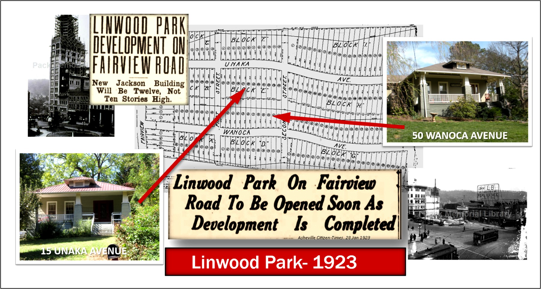
“LINWOOD PARK DEVELOPMENT ON FAIRVIEW ROAD— NEW JACKSON BUILDING WILL BE TWELVE NOT TEN STORIES HIGH”, was the duel headline from a December 10, 1922 article in the Asheville Citizen Times.[xxxiv] Lynwood B. Jackson, known simply as “LB”, was an energetic and ambitious young man of only 27 years old, who was not only fast becoming a real estate mogul, but was about to construct Asheville’s first skyscraper. In 1922, Jackson purchased 25 acres on the south side of Fairview Road from the Erwin Patton estate and platted out a new development to be called “Linwood Park”.[xxxv] The new development was “pronounced as among the most attractive suburban sections in the vicinity of Asheville” and boasted “an excellent view of the surrounding mountains… including Pisgah and The Rat.” [xxxvi] The new park had two main streets running north-south, Wanoca and Unaka Avenues. It was announced in January 1923 that Linwood Park would open in thirty days and would have “several residences costing approximately $20,000 [together]” that “will be under construction when the property opens for the erection of residences.”[xxxvii] One of the residences that was built at the start, or at least under construction, was the house on “Lots 9-10, Block E”, now known as 50 Wanoca Avenue. This is evidenced by the fact that in May of 1923, the Asheville Investment Company (another LBJ company) sold the property to LB’s brother, Robert P. Jackson, along with an indebtedness of $2,500.[xxxviii] At the same time Robert Jackson also purchased the property at Lots 15-16 of Block E, on Unaka Avenue (#15 Unaka)[xxxix], which also came with the same amount of indebtedness, and which in design is an exact copy of 50 Wanoca Ave, obviously both were built by Linwood B. Jackson and then sold to Robert Jackson of the Jackson Realty to be marketed and sold to new homeowners. An early advertisement of Jackson Realty gives a good description of this new development- “LINWOOD PARK IS NOT A Rich man’s residential section but is one of the prettiest places in the county to live. You get a perfect view of the mountains-what a rich man pays thousands for in other parts of the city. You get everything he gets in a lot, but you get it for a very amount and on terms that you can pay for it easy.”[xl]
Amongst all this increased growth and development in Oakley came the startling announcement late in December of 1923 that Sayles Finishing Plant of Pawtucket, Rhode Island had recently purchased a large chunk of the Cheesborough estate lands, 200 acres, on which they planned to erect a new two-million dollar “cotton bleachery and a modern housing community along the Swannanoa River.”[xli] The site of this new plant and community was to be just across the railroad tracts north of Fairview Road. “Along with erection of the mill,” it was further announced, “will come the establishing of a model village, not of the occasional monotonous mill village, officials make it plain, but a well planned community of nice cottage and bungalow type homes, with all modern conveniences and appliances to house those of the employees who desire such homes. At the same time, the policy of urging employees to buy and own their own properties, will be fostered it is stated”.[xlii]
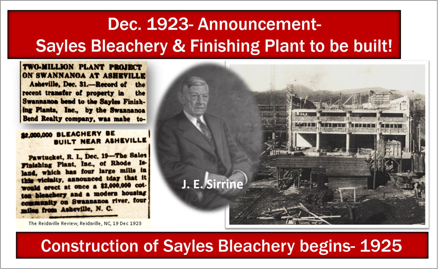
J. E. Sirrine & Company of Greenville, SC was hired to design and construct both the bleachery plant and the village houses. Joseph Emory Sirrine, trained as an engineer, established the firm of J. E. Sirrine & Company in 1902. The company operated much like a design-build firm providing architectural design, engineering, and construction. Throughout the first half of the twentieth century, up until Sirrine’s death in 1947, J. E. Sirrine & Company was one of the leading design and construction consultants of the cotton textile industry. Robert Fuller, an architect with J. E. Sirrine was the project architect for the Sayles project. Construction of the plant began in 1925.
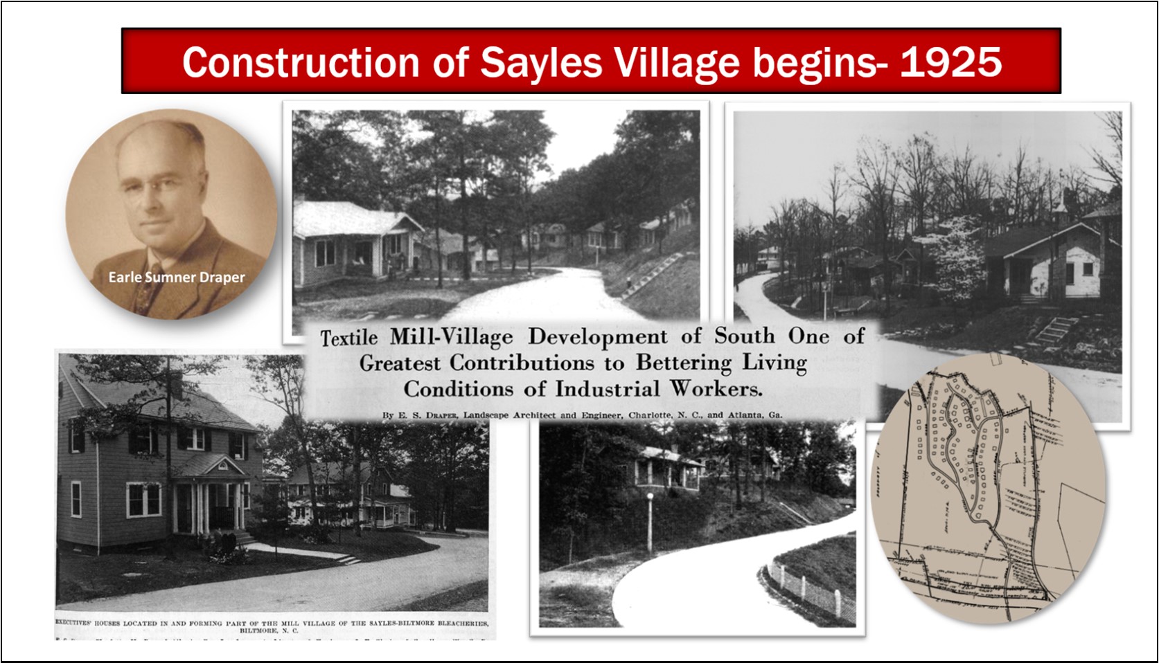
E. S. Draper, Landscape Architects, of Charlotte, NC were hired as the site designers for both the Bleachery grounds and the Village. Earle Sumner Draper, a graduate of Massachusetts Agricultural College, established the firm of E. S. Draper, Landscape Architects in 1917. In a 1926 article, from the Manufacturer’s Record, titled “Textile Mill-Village Development of South One of the Greatest Contributions to better Living Conditions of Industrial Workers”[xliii], Draper writes that in the 1920’s in the South that new mills being built have “considered attractive villages, with the necessary improvements of sewer and water systems, lighting, street surfacing, sidewalks, and well-designed mill houses, as just as important as proper machinery layout in the plant. Such new plants as Sayles-Biltmore Bleachery, at Biltmore, NC close to Asheville, where probably the finest single textile village in the South is now being completed.” “Of course, the governing factor which must be first be considered in any layout is the topography,” writes Draper. In the same article he provides photos of Sayles Village, and captions that the village site was designed with the “site terraced on sloping ground, leaving as much of the natural wooded growth as possible.” And that the houses were sited “with careful location and adjustment of grades”. In addition to the houses, Draper also designed the site for various community activities and structures such as a community clubhouse, ball fields, gardens, and grouped automobile garages. Also, at the same time (1925-26) E. S. Draper’s firm was designing a swanky new golf community, to be named “Beverly Hills”, just across the Swannanoa River within eyesight of the Bleachery.
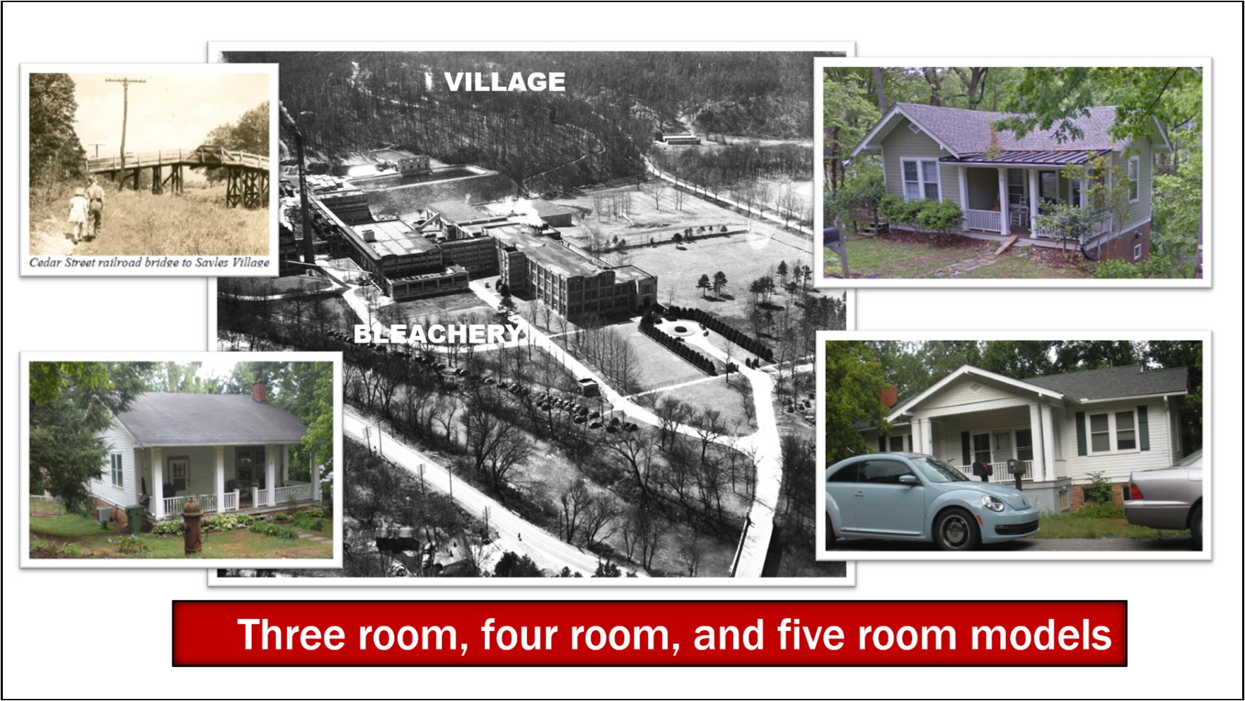
The village houses themselves were designed by Robert B. Fuller of J. E. Sirrine & Co. of Greenville, SC. Fuller designed three types of one-story homes for the workers– “a three room” (one bedroom), “four room” (two bedroom), and a “five room” (three bedroom). The houses were designed with electricity and indoor plumbing. In addition to the workers’ homes (or “operatives’ cottages” as Draper called them) Fuller designed two-story Colonial-revival homes for the executives, which were built on Ridge Road at the top of the village. None of the executive houses remain. A wooden “hump bridge” was eventually built over the railroad tracks on the north end of the Village which connected Wood Avenue (in the village) to Cedar Street, thereby connecting the village to Oakley. Of course, that wooden bridge has long been replaced with a flat concrete bridge. In 1962, Celanese Corporation of America, who then owned and operated the Bleachery, divested themselves of the village houses and sold them to the workers. In the 1970’s Interstate 240 cut a swathe dividing the mill and village and causing the loss of several houses. The Bleachery closed in 1991, and after years of cleanup of the “Superfund site”, the mill was torn down and the property developed into a Walmart and other retail stores and multi-family apartment complexes.
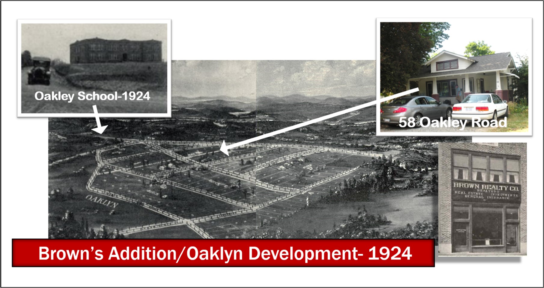
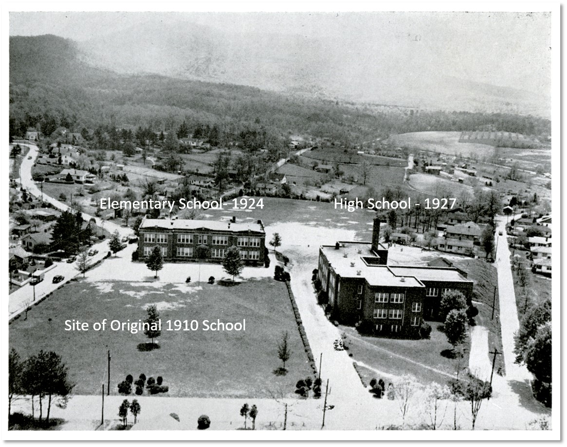
Although the development of Oakley in the mid-1920’s was not an organized “plan” coordinated directly with the building of the Sayles Bleachery and Village, it is clear that the arrival of the Bleachery with its potential new homeowners, who were being encouraged “to buy and own their own properties”, was an impetus for increased development of Oakley. In May of 1924, just a few months after the announcement of the building of the Syales Bleachery and Village, developer Robert S. Brown, of Brown Realty Company, reported that he “is planning a large development at Oakley, on Fairview Road, just two miles east of Biltmore”.[xliv] He further reported the development, which was planned to be subdivided into business properties and residential lots, was “almost adjoining the new $50,000 Oakley School”[xlv], which was currently being erected. This school, which was shown in a Brown Realty advertisement for their new development, is still standing and is part of the current-day Oakley Elementary School campus.
Brown Realty began selling lots for their new Oakley development in June of 1924. As a sales tool (gimmick), Brown Realty began announcing in June of 1924, a “Free Picnic Lunch” would be provided on-site at “Brown’s Addition” (temporary name), from 4:00-7:00 pm every day that week (except Sunday), with the further enticement that all would eligible to submit a name for the development, with the winner receiving a “a beautiful lot free, and a cash bonus”.[xlvi] The wining name, chosen out of the “approximately 4000 names suggested”, which was suggested by “Contestant No. 71… Mr. R. B. Horsburg of 65 Virginia Avenue, West Asheville,” for its excellence in “association, Euphony, and brevity”, was the simple name of “Oaklyn”.[xlvii] The new “Oaklyn” subdivision was designed to appeal to working, middle-class families, as it was advertised as “being designed to meet the needs of the average man for a semi-suburban locality that would combine beauty, accessibility and moderate price.” And although the prices of the lots were “well within the reach of the average,” the subdivision still boasted modern conveniences such as “water, light, sewage and paved streets throughout.”[xlviii] “Oaklyn” lies north of Onteora and is bordered on the north and west by Fairview Road and on the east by Wilmington Road. The house at 58 Oakley Road, is an example of the type of houses that were first built in Oaklyn.
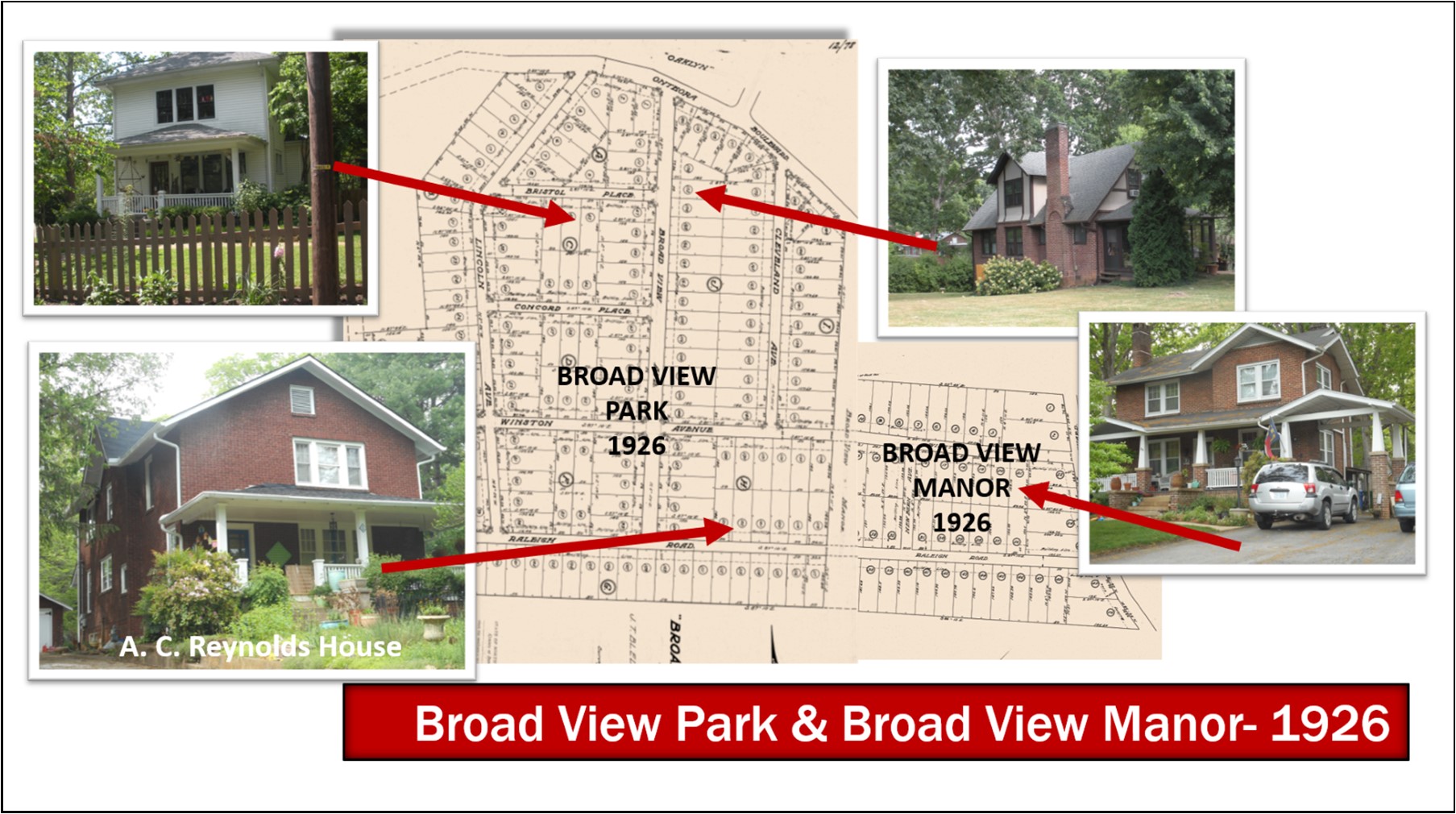
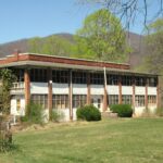
Developers J. T. Bledsoe & N. T. Robinson joined forces in 1925 to begin developing two subdivisions in Oakley, “Broadview Park” and “Broadview Manor”. Robinson and Bledsoe were partners in the firm of J. T. Bledsoe & Company. The company was a general real estate brokerage that was also engaged in development projects around Asheville in the 1920’s. Broadview Park was platted in February of 1926 and Broadview Manor was platted in May of 1926. Both opened in 1927. The first, Broadview Park, was platted in February of 1926. Two years later, in February 1928, Bledsoe-Robinson Development Company sold Lots 120 & 121 of Block H to Professor Alonzo Carlton Reynolds and his wife Nannie. The house at 86 Raleigh Road that Reynolds built on his newly purchased lot, is a two-story, rather plain brick house. The house, although having hints of the Arts & Crafts styling, seems to have been designed with no specific “style” in mind. Its distinguishing features are its beautiful large front porch and original detached garage. Reynolds served as superintendent of Buncombe County schools from 1926–33. Also, during this time Reynolds was instrumental in the establishment of the Biltmore Junior College (begun in 1927) where he served as its first president until 1936. Although the house at 86 Raleigh was sold in 1933, after Reynolds defaulted on the mortgage, the Reynolds family continued to live in the house until 1936 at which time the family moved as Reynolds had accepted the position of principal at Barnardsville High School. He returned to Oakley High School in 1938 and moved his family back to Oakley until his retirement in 1942. “A. C. Reynolds High School” is named for this former local teacher and administrator.
Of course, all the increased development and influx of new families into the Oakley neighborhoods created an increased number of students at the Oakley School. In fact, although a new two-story school had been built in 1924, an additional building was needed and constructed in 1927, at the corner of Liberty and Fairview Road, on land purchased from J. L. Murphy, which had previously been platted as part of Murphy’s 1924 “Oakley Park” development. The new building, which sat perpendicular to and in front of the 1924 building, was used as a high school with the 1924 building functioning as a grammar school. This 1927 building has now been replaced by a parking lot.
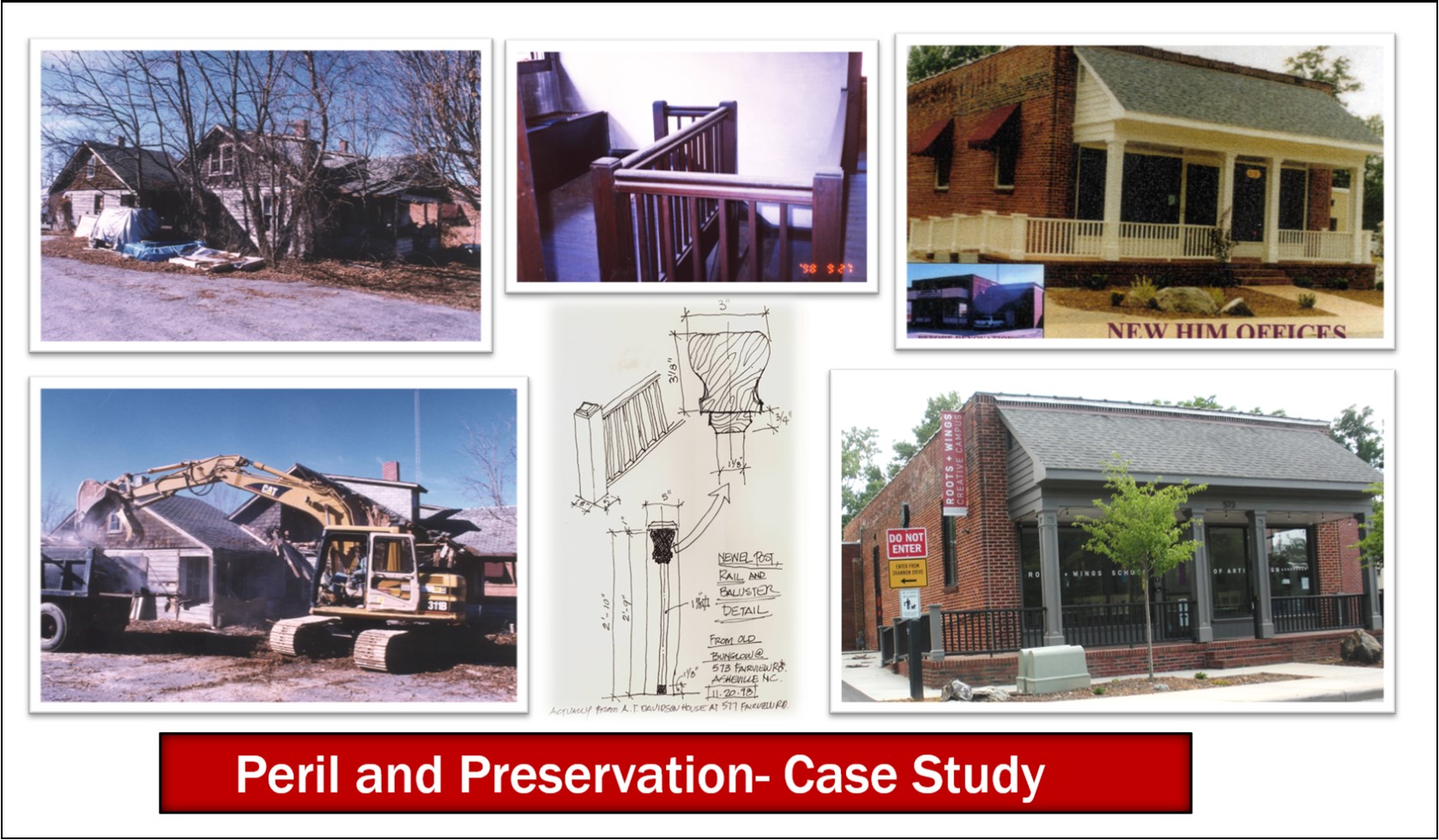
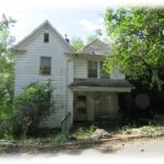
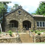
To end our discussion on the development of Sayles Village and Oakley, I would like to briefly make a case for Historic Preservation in our Oakley community. The case can be made through the example of a project to which I am very familiar–the properties at 573 & 577 Fairview Road. It is both an example of peril and preservation. In 1998, Helps Ministries, of which I am a member, purchased the old brick building and property at 573 Fairview Road. The property also included a dilapidated 1920’s bungalow that was sandwiched in and surrounded by paved parking. I have since discovered that the bungalow was the home of the A. T. Davidson family at 577 Fairview Road. Davidson was a storekeeper, first at his own store at the corner of Glendale Avenue and Fairview Road (600 Fairview Road) and later he was the active partner in Davidson-McChesney General Merchandise which he built and operated next door at 573 Fairview Road. By the time Helps Ministries purchased the properties, the bungalow was in poor condition having been neglected for decades, and so it was demolished in late 1998. Although I did not prepare measured drawings prior to the demolition, I did measure and sketch the uniquely simple but elegant interior stair rail. In counterpoint to the loss of the property at 577 Fairview was the saving and rehabbing of the adjacent brick store, the former Davidson-McChesney General Merchandise at 573 Fairview Road. Helps Ministries not only rehabbed the building in 1999, but also tore down the perimeter chain link fencing and landscaped the property and returned the property to an active and open member of the Oakley community. The current owners, purchased the property from Helps Ministries in 2014, and in an award-winning rehabilitation turned the building into the Roots & Wings School of Art & Design. Roots & Wings was awarded a 2016 Griffin Award for PSABC for their rehabilitation.
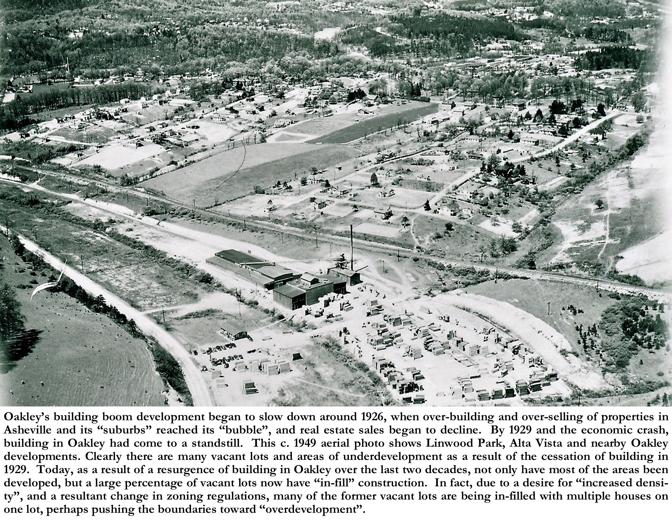
Oakley’s building boom development began to slow down around 1926, when over-building and over-selling of properties in Asheville and its “suburbs” reached its “bubble”, and real estate sales began to decline. By 1929 and the economic crash, building in Oakley had come to a standstill. Today, as a result of a resurgence of building in Oakley over the last two decades, not only have most of the vacant areas been developed, but a large percentage of vacant lots now have “in-fill” construction. In fact, due to a desire for “increased density”, and a resultant change in zoning regulations, many of the former vacant lots are being in-filled with multiple houses on one lot, perhaps pushing the boundaries toward “overdevelopment”.
The good news is that much of Oakley’s historic housing stock, as well as its historic public buildings, remains today, adding to the charm and desirability of Oakley as a modern-day neighborhood. Also, new neighborhoods are being developed on unsold tracts of land from the 1920’s development by being “re-developed”. Take for example, “Biltmore Terrace” off School Road, which was first platted in 1926.[xlix] Except for a few lots along School Road, little was developed in Biltmore Terrace in its first development during the 1920’s. But then in 2005, a group of investors called Biltmore Terrace Development, LLC purchased many of the vacant lots on both sides of Lamar Avenue and built new single-family homes on the many vacant lots, keeping the original “Biltmore Terrace” development name as well as keeping the original street names. “In-Fill” development, like Biltmore Terrace, if done correctly-by keeping the new buildings in scale to their neighboring properties, is an effective way to preserve our historic neighborhoods, like Oakley, while also continuing to grow and develop our neighborhoods into active and desirable places to live and work.
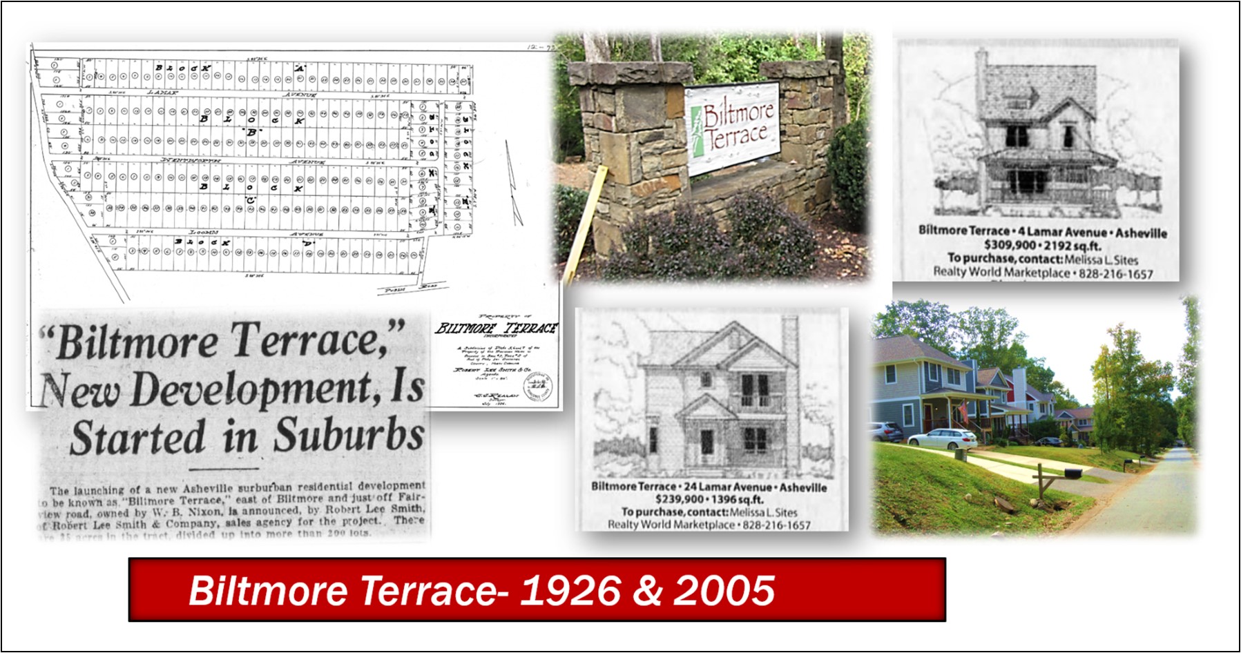
Photo & Image Credits: (Note: All cropping and captions by author
All Modern Map Images– Googlemaps.com
All Colored photos– by Dale Wayne Slusser
All Plats– Buncombe County Register of Deeds https://registerofdeeds.buncombecounty.org/External/LandRecords/protected/v4/SrchName.aspx
All newspaper articles or advertisements– from newspapers.com
Brazier Map– “A New Map of the State of North Carolina”, by Robert H. B. Brazier (Fayetteville, N.C. : Published under the patronage of the legislature by John Mac Rae Philadelphia : H.S. Tanner, 1833). https://www.loc.gov/item/2006459002/
Joseph Reed Portrait– Series 4. Pictures, 1865-1979, and undated. Special Format Image SF-P-5179/3 – Joseph Reed III (1827-1884), Large painted portrait. Collection Number: 05179- Reed Family of Buncombe County, N.C., Papers, 1816-1996. Wilson Special Collections Library at the University of North Carolina at Chapel Hill. – https://finding-aids.lib.unc.edu/05179/#sfimage_3#1
Joseph Reed Estate Plat/Survey– “Plat of Joseph Reed’s Foster Farm”, “Drawn and Divided, Nov. 1884”. -BHA1-00215 -Biltmore Estate Drawings Collection- Biltmore Estate Archives, 1 North Pack Square, Asheville NC 28801.
Joseph Reed House- BHA4-01868_Cropped- Biltmore Estate Archives, 1 North Pack Square, Asheville NC 28801.
1903 Buncombe County Map– ID. MAP501- Road Map of Buncombe County North Carolina copyright 1903 by H. Taylor Rogers, B.M. Lee, Civil Engineer, Asheville, NC. -Buncombe County Special Collections, Pack Library, Asheville, NC.
Stevens Plat/Survey– “Plat of Henry Stevens Land”, Surveyed March 13-14, 1861 by Sam’l. S. Brown. – BHA1-00217 -Biltmore Estate Drawings Collection- Biltmore Estate Archives, 1 North Pack Square, Asheville NC 28801.
1917 Oakley School Students and Faculty– from the files in the Offices of Oakley Elementary School, 753 Fairview Rd, Asheville, NC.
Sayles Bleachery Aerial Photo– ID. D135-5 – Bingham aerial view from packet A-69: “Sayles Bleachery, Biltmore, NC…4/25/49” – Buncombe County Special Collections, Pack Library, Asheville, NC.
Brown’s Addition/Oaklyn Images– ID. MS028.022P – “The Brown Book” brochure for the Brown Realty Co. with handwritten date of 1926. -Buncombe County Special Collections, Pack Library, Asheville, NC.
Oakley Schools Photo-ID. M055-DS – Scan of Oakley School, as it appeared around 1952, taken from page 49 of the 1952 Oakley Oak, the Oakley High School student annual. -Buncombe County Special Collections, Pack Library, Asheville, NC.
Live and Invest in the Land of the Sky Cover– 1920s. D. H. Ramsey Library, Special Collections, UNC Asheville.
Asheville City Plan– “Asheville City Plan” by John Nolen, (1869-1937) Asheville, North Carolina, [City Planning Commission], 1922. –https://archive.org/details/cu31924024412185
[i] From an advertisement for Foster’s estate in 1859- Asheville News, Asheville, NC, February 10, 1859.
[ii] John W. Woodfin Est– Nicholas W Woodfin, Exec to Samuel Whedbee, Buncombe County Register of Deeds, Deed Bk. 29 page 23.
[iii] 12/06/1871 J. G. & Annie Hardy to Joseph & Catherine Reed, Main Street, Buncombe County Register of Deeds, Deed Bk. 34, page 368.
[iv] 12/26/1872 James S. Whedbee; Admin. -Samuel Whedbee to Joseph Reed, Buncombe County Register of Deeds, Deed Bk 37, page 132.
[v] “Best, Swannanoa Bridge, Biltmore or Foster Place”, by C. Bruce Whitaker, Fairview Town Crier, August 3, 2017- https://fairviewtowncrier.com/2017/08/best-swannanoa-bridge-biltmore-or-foster-place/
[vi] Proceedings recorded in the “Special Proceedings” book 4, page 104- Buncombe County Superior Court, and Book 70, pp. 105-145, Buncombe County Register of Deeds, Asheville, NC.
[vii] Survey now the property of the Biltmore Estate- “Joseph Reed’s Foster Farm, Drawings Collection, BHA00215, Biltmore Estate Archives, Asheville, NC. See also Deed: 04/18/1890- James E. Reed, Johnson Ashworth, & Joseph Miller, Commiss. Estate of Joseph Reed to S. H. Reed; M. L. Reed; T.J. Reed; Lula M. Reed; Hattie E. Reed, Tenants in Common SWANNANOA RIVER SWEETEN CREEK (“Foster Farm”; “Lusk Farm”; “Jos. Reed Busbee Mountain Farm”) Db. 70/121. Buncombe County Register of Deeds, Asheville, NC.
[viii] 11/21/1891 M. L. & S. B. Reed to Otis A. Miller 114 ACRES HICKORY NUT GAP ROAD Db. 80/164; and 11/21/1891 S. H. & Jessie M. Reed to Otis A. Miller 96 ACRES HICKORY NUT GAP ROAD Db. 80/166. -Buncombe County Register of Deeds.
[ix] Asheville Citizen-Times, July 31, 1897, page 4. -newspapers.com
[x] 10/22/1840 (rec’d-07/06/1888) Jeremiah West to John Long, Foster M. Wilson, Jeremiah West-trustees CHURCH & SCHOOL SITE Db. 63/115. -Buncombe County Register of Deeds.
[xi] 01/19/1913 Edwin L. Gaston PLAT BILTMORE Db. 154 / 114. -Buncombe County Register of Deeds.
[xii] 05/23/1908 H. L. Steele PLAT HICKORY NUT GAP RD NEAR SOUTHERN RAILROAD BILTMORE Db. 157/267. -Buncombe County Register of Deeds.
[xiii] 10/01/1909 E. W. Patton -PLAT BILTMORE NC Db. 154/29. -Buncombe County Register of Deeds.
[xiv] 11/01/1920 E. W. Patton -PLAT BILTMORE NC Db. 2/31. -Buncombe County Register of Deeds.
[xv] Asheville Gazette-News, October 1, 1912, page 6. -newspapers.com
[xvi] 05/25/1905 R. B. & Juliet Opie Ayres to J. L. & Hessie Murphy COURTLAND AVENUE Db. 136/282. -Buncombe County Register of Deeds.
[xvii] See ancestry.com to verify these details.
[xviii] Ibid.
[xix] Ibid.
[xx] 07/17/1912 J. G. & Nancy J. Stikeleather to J. L. & Hessie Murphy 2 TRACTS SWEEDENS CREEK & HICKORY NUT GAP RD Db. 178/101. -Buncombe County Register of Deeds.
[xxi] 09/18/1913 J. L. & Eva Murphy to Thomas R. & Ida M. Reed FAIRLAND PARK- LOT 3 Db. 188/280. -Buncombe County Register of Deeds.
[xxii] 06/26/1915 J. L. & Eva Murphy to David J. Quinn FAIRLAND PARK LOT 1 Db. 201/79. -Buncombe County Register of Deeds.
[xxiii] 01/20/1916 J. L. & Eva Murphy to W. W. Quinn FAIRLAND PARK Lot 2 Db. 205/336. -Buncombe County Register of Deeds.
[xxiv] 02/28/1916 J. L. & Eva Murphy to H. M. Cauble ASHEVILLE TS FAIRLAND PARK Lot 4 Db. 205/544. -Buncombe County Register of Deeds.
[xxv] Asheville Citizen-Times, February 1, 1910, page 8. -newspapers.com
[xxvi] Asheville Citizen-Times, July 14, 1910, page 5. -newspapers.com
[xxvii] 10/13/1910 Erwin W Patton to BD EDUCATION BUN CO (6 ACRES HICKOR NUT GAP ROAD) Db.171 / 619. -Buncombe County Register of Deeds.
[xxviii] Asheville Citizen-Times, October 9, 1910, page 5. -newspapers.com
[xxix] From: “A History of Oakley School”, by former faculty member Elizabeth H. Redmon. Redmon’s history and the 1917 photo of the students and faculty of Oakley School, are from the files in the Offices of Oakley Elementary School, 753 Fairview Rd, Asheville, NC.
[xxx] “Asheville City Plan”, by John Nolen, Asheville, NC, 1922. -Internet Archive: https://archive.org/details/cu31924024412185/page/n5/mode/2up
[xxxi] “Live and Invest in the Land of the Sky”, 1920s. -D. H. Ramsey Library, Special Collections, UNC Asheville, Asheville, NC.
[xxxii] “EASR BILTMORE WATER COMPANY CHARTERED”, Asheville Citizen-Times, March 17, 1919, page 5. -newspapers.com.
[xxxiii] See: 06/01/1920 Reed & McCall PLAT BILTMORE, Db. 1/60; and 06/01/1920 Reed & McCall PLAT BILTMORE, Db. 1/67. -Buncombe County Register of Deeds.
[xxxiv] “LINWOOD PARK DEVELOPMENT ON FAIRVIEW ROAD— NEW JACKSON BUILDING WILL BE TWELVE NOT TEN STORIES HIGH”, Asheville Citizen-Times, December 10, 1922, page 1. -newspapers.com.
[xxxv] 04/03/1923 LINWOOD PARK, PLAT-BLOCK A TO I ON FAIRVIEW ROAD Db. 5/1. -Buncombe County Register of Deeds.
[xxxvi] “Linwood Park On Fairview Road To Be Opened Soon As Development Is Completed”, Asheville Citizen-Times, January 28, 1923, page 13. -newspapers.com.
[xxxvii] Ibid.
[xxxviii] 05/28/1923 Asheville Investment Company to Robert P. Jackson; Charles E. Lee LOTS 9-12 BLK E BK 5 P 1 Db. 268/133. -Buncombe County Register of Deeds.
[xxxix] 05/28/1923 Asheville Investment Company to Robert P. Jackson; E. W. Stapleton; Mary Robeson Corry LOTS 15-16 BLK E BK 5 P 1 Db. 268/147. -Buncombe County Register of Deeds.
[xl] Asheville Citizen-Times, August 3, 1923, page 17. -newspapers.com.
[xli] “TWO MILLIONS TO BE COST OF NEW BLEACHERY PLANT”, Asheville Citizen-Times, December 14, 1923, page 1. -newspapers.com.
[xlii] Ibid.
[xliii] “Textile Mill-Village Development of South One of the Greatest Contributions to better Living Conditions of Industrial Workers”, by E. S. Draper, Landscape Architect and Engineer, Charlotte, N.C. and Altlanta, Ga., “Maufacturer’s Record, Volume XC No. 17, Weekly, October 28, 1926” (Baltimore, MD) pages 111-113.
[xliv] Asheville Times, May 11, 1924, page 56. -newspapers.com
[xlv] Ibid.
[xlvi] Asheville Citizen-Times, June 15, 1924, page 42. -newspapers.com
[xlvii] See advertisement/announcement of Oaklyn: Asheville Times, August 3, 1924, page 24. -newspapers.com.
[xlviii] “The Brown Book” brochure for the Brown Realty Co. with handwritten date of 1926, page 16. -ID: MS028.022P, Buncombe County Special Collections, Pack Library, Asheville, NC.
[xlix] 07/23/1926 BILTMORE TERRACE PLAT BUNCOMBE COUNTY Db. 12/73. -Buncombe County Register of Deeds.