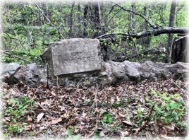
by Dale Wayne Slusser
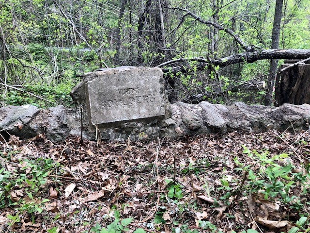
An East Asheville homeowner inquired of the Preservation Society, if anyone in the Society knew anything about the mysterious dressed granite stone, incised with the name “WHITE BOULDERS”, which sits on top of a low stone wall along Old Chunns Cove Road, just above the east portal of the Beaucatcher Tunnel? The homeowner, who lives just above the site of the mysterious stone, and just below the famous Zealandia estate, also inquired as to the possibility that it had something to do with Zealandia? And I confess that for a good bit of my research into the mystery, I too assumed that it had something to do with Zealandia. However, after long hours of going down the Zealandia trails, I suddenly discovered that not only did it not have anything to do with Zealandia, but that “White Boulders” has its own intriguing history and story to tell!
What is “Zealandia”? And why would we have assumed that the “White Boulders” stone was associated with it? Why did we just automatically assume that the mysterious incised stone, “White Boulders”, was part of the Zealandia? Simply because it lies on the east slope of Beaucatcher, just below the ridge where Zealandia sits. And since Zealandia has occupied that entire section of the Beaucatcher ridge since 1888, being highly visible from both the west and east, it was logical to assume that the two were connected.
In 1888, shortly after returning from living in Australia and New Zealand for twenty years, Mr. John Evans Brown, purchased five acres on top of Beaucatcher Mountain. Mr. Brown was a native of Lewiston, Pennsylvania, where he was born on the 16th of February, 1827. He crossed the Continent in 1849, going to California, where he engaged in surveying. After a few years he removed to New South Wales, and there carried on a sheep and cattle business on an extensive scale. He also served as the United States consul in New South Wales for several years. In 1864 Mr. Brown moved to New Zealand. Brown was twice married; his first wife, to whom he was married in 1857 in New South Wales, was a sister of the Hon. J. T. Peacock and Mrs H. R. Webb of Christchurch. His second marriage was contracted with Mrs Martin, of Wellington, in 1883.[1] J. Evans Brown, prior to moving to Australia and New Zealand, had lived in Buncombe County with his parents in the 1840’s, having moved to Buncombe around 1842 at the age of 15.[2] Brown’s father, Major William J. Brown, who had remained in Asheville/Buncombe County until his death in 1884, in the 1850’s and 1860’s had purchased large tracts of land in Buncombe County as an agent for his son J. Evans Brown. So, it’s not surprising that J. Evans Brown returned to Asheville in 1885.
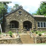
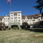
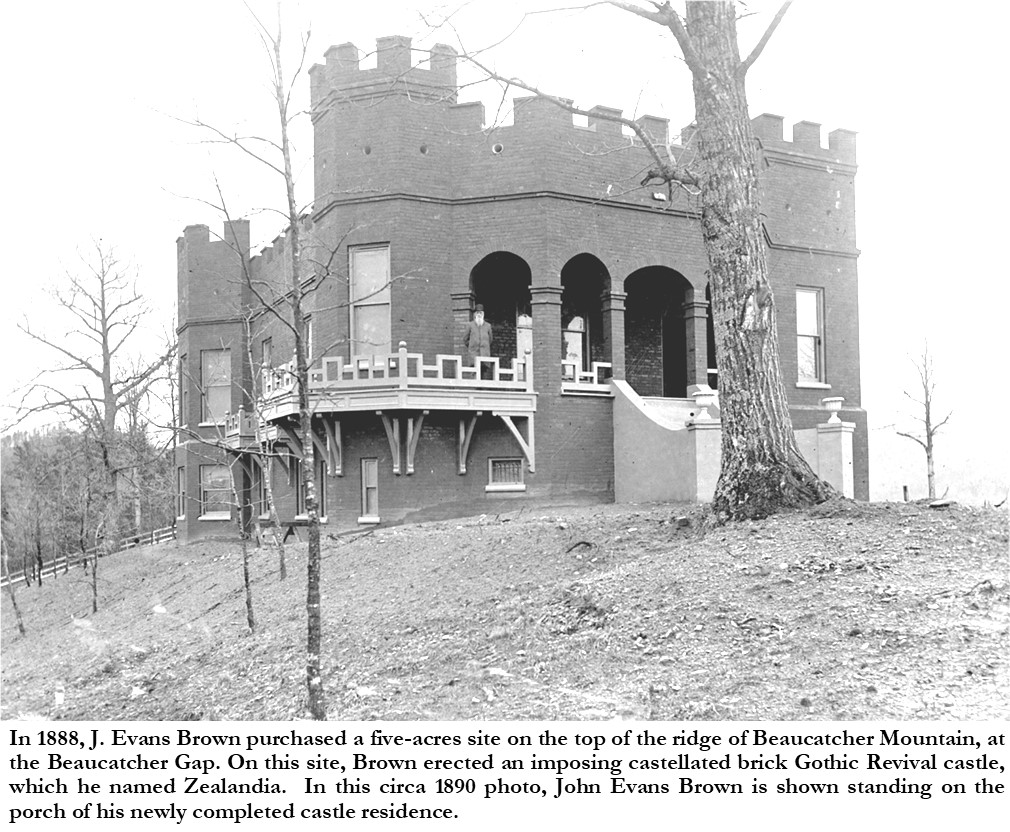
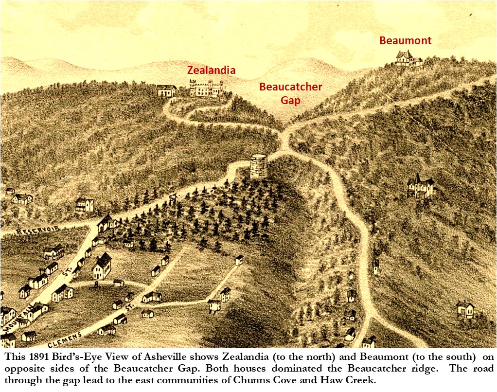
On his newly purchased site, which was on the top of the ridge of Beaucatcher Mountain, at the Beaucatcher Gap, Brown erected an imposing castellated brick Gothic Revival castle, which he named Zealandia. It’s ironic that Brown should build his mansion on Beaucatcher Mountain, as his father, Major William J. Brown, is credited with having given the mountain its name. According to an 1889 report, “Beaucatcher originated in this way: Mr. James W. Patton, father of Capt. Patton, built a summer house on the summit, of the mountain, about where Mr. Hazzard’s home now stands. Mr. William J. Brown, father of J. Evans Brown, in teasing a well known lady of this city called this summer house her “beaucatcher”, and hence the name.”[3] Zealandia was built just north of the Beaucatcher Gap, which was then the major route over/through the mountain from Asheville to the Haw Creek and Chunns Cove communities to the east. “Mr. Hazzard’s house”, named “Beaumont”, had recently been built just south of the gap. In fact, a later owner of Zealandia, Mr. Phillip S. Henry, also purchased Beaumont and erected a bridge (known today as “Helen’s Bridge”) to connect the two properties.
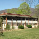
John Evans Brown died at Zealandia in 1895[4]. In 1901, Brown’s widow, Jane Emily Brown, sold Zealandia and its five acres, to O.D. & Caroline Revell.[5] Then in 1904, Sir Phillip S. Henry, an Australian born diplomat acquired Zealandia. P. S. Henry greatly improved the estate in the ensuing years, beginning in 1905, when he commissioned architect Richard Sharp Smith, to design a three-story stable/carriage house. Henry built the stables on the east side of the house on the east slope of Beaucatcher. Beginning in 1907, Henry began extensive renovations to the castle, and then in 1910, the castle was doubled in size with a granite and stucco-faced addition, designed by Richard Sharp Smith. P. S. Henry, an avid art and artifact collector, first opened a small museum in a wing of Zealandia, but then in 1928, he built a separate building on the estate to house the museum. After P. S. Henry’s death in 1933, the property was inherited by Henry’s two daughters, Violet & Lenore Maconochie, who had married British brothers.[6] In 1950, Violet, and her husband, Hartley Maconochie, for safety and economic reasons, greatly reduced the size of the castle. They tore down the original Brown sections of the castle, as well as some of the Henry additions, and “trimmed to about 10 rooms”.[7] In a further effort to reduce the estate, at that time the Maconochies also sold off portions of the estate. The northern section was subdivided into lots and developed into a subdivision with its central street named Boxwood Lane, and the Maconochies also sold Beaumont, and sold off the museum building as well.

Once I realized that Zealandia was held by the Henry family until the 1960’s and had always been called Zealandia, then I knew that “White Boulders” was never used as the name for Zealandia. But then what about the museum building, as a 1950 newspaper article indicated that it was sold to an Edmund P. Gaines and turned into a residence? Upon further investigation, I discovered a photo showing the museum/Gaines house sitting just above an entrance to the Beaucatcher tunnel? Ahaa-I thought, Gaines may have named his house “White Boulders”? But alas, upon further investigation down that trail, by comparing maps and plats, and re-reading the description on the photograph, I discovered that the museum/Gaines house was located above the WESTERN portal to the tunnel, putting it on the opposite side of Beaucatcher from the mysterious stone.

With the trails to any connection to Zealandia having gone cold, I then refocused my investigation on trying to connect the mysterious stone to two or three items that I have previously found searching newspapers.com. In fact, these items were so obviously connected to the “White Boulders” stone, that I felt ashamed that I had wasted so much time looking into the Zealandia connections. On September 17, 1923, the following advertisement appeared in the Asheville Citizen-Times, “WANTED- 100 yards of stable manure, highest price paid delivered at “White Boulders” 1-4 mile east of Beaucatcher Mountain, Chunns Cove, Walter Walden. R. F. D. No. 2.”[8] The name “White Boulders” was an obvious connection, and the “east of Beaucatcher Mountain, Chunns Cove” was obvious as well, since the mysterious stone is on Old Chunns Cove Road or the east side of Beaucatcher! So, who was “Walter Walden”, and did he ever own the land where the stone is located? A quick search of the database of Deeds at the Buncombe County showed a “Walter F. Walden”, however he purchased property only after 1922, and never in the vicinity of the stone.
But then a second advertisement published in December of 1923, revealed further confirmation as well as another lead. The advertisement read as follows: “WANTED- 200 pine poles 22 feet long and not less than 6 inches diameter, at small end and 8 inches at large end. Also 200 smaller poles 12 ft. long, 3 inch diameter at small end, 6 inches at large end, all bark removed and delivered at White Boulders “600 feet of Beaucatcher Mountain” Chunns Cove. State lowest price, and etc, to P. O. Box 598, Miami, Florida.”[9] Obviously, compared with the earlier article, “White Boulders” had some type of agricultural component to it, the “600 feet of Beaucatcher Mountain” meant it was obviously on a slope or ridge of Beaucatcher. But what about the Miami address? And could I connect that with the “Walter Walden” of the previous advertisements? It turned out that those two connections, to use modern TV detective lingo, were what “blew the case wide open!”. Although those connections would take a bit of sleuthing to reveal the answers and connections to the mysterious stone along Old Chunns Cove Road.
In order not to bore you with the minutia of my search for a connection between “Walter Walden” and Miami, Florida, suffice it to say that “Walter Walden” turned out to be “Walter Waldin”! Walter Waldin was a German-born agriculturist (farmer) turned real estate investor who was well known in early twentieth-century Miami society. Walter Waldin was born on May 7, 1862 in Gern, Germany to Anton & Johanna Waldin. “His father, an officer in the German army, came to this country to offer his services to the federal government during the Civil War. He settled at Burlington, Ia. with his family in 1864”.[10] Walter Waldin, as a young adult, became a successful farmer and experimental agriculturalist in Iowa. His experiences and experiments were often recorded in contemporary periodicals. In 1897, Waldin published an article, along with photos, in the “Rural New Yorker”, titled: “An Irrigation Idea from Iowa: Fish and Fertility From a Pond, An Earthen Dam In a Ravine”. As the title indicated, Waldin told of his experiment to dam up a creek in a ravine on his 80-acre farm in Iowa, to not only use the land below the dam for producing crops, but also then using the pond water for irrigation. The success of this experiment would prove useful, when in 1898 he moved his family to the Everglades of Florida. In 1902, Waldin purchased over 100 acres of undeveloped land in the Everglades of Dade County “and improved and developed it into “Fern View Farm”, one of the largest and most profitable farms in the state.”[11] “At a time when farmers were struggling to survive on 160-acre homesteads out west, the farmer Walter Waldin netted $3,400 on six acres in six months in the Everglades—after building a home and feeding a family of five.”[12] In 1910, Waldin put his experiences and experiments into a book which he titled: Truck Farming In the Everglades.[13] But the following year, 1911, Waldin sold his farm and entered the real estate business, where he incorporated the “Walter Waldin Investment Company”.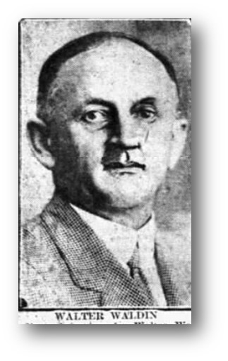
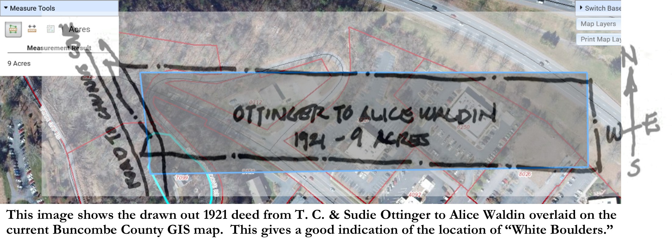
So how did I confirm the connection of Walter Waldin of Miami with the “White Boulders” stone? On the strength of having the correct spelling of Waldin, I went back to the Buncombe County deeds database, and searched under “Walter Waldin”. Although that was unsuccessful, a search using just “Waldin” revealed that an Alice Waldin (“of the County of Dade in the State of Florida”), had purchased a nine acre property in September of 1921 from T. C. & Sudie Ottinger, with a deed description saying, “Beginning at a stake in the road that leads from the Gap in Beaumont Mountain towards the head of Chunn’s Cove…”.[14] It was easy then to discover that Alice Waldin was the second wife of THE Walter Waldin of Miami, Fl. And a subsequent chain of title search, both before and after the Waldins’ ownership, revealed that the mysterious “White Boulders” stone is indeed in the right vicinity!
Where exactly was the “White Boulders” farm? By drawing out the deed descriptions on several of the property transfers, as well as overlaying them over the existing Buncombe County GIS (Geographic Information System), the exact location became clear. All the deeds indicate that the western boundary was along, what is now called Old Chunns Cove Road, originally called Chunns Cove Road, and described in the deeds as “the road that leads from the Gap in Beaumont Mountain towards the head of Chunn’s Cove”. The 9-acre property was mostly one long rectangle 265 feet wide (north to south) by 1550 feet long, stretching from Chunns Cove Road (slightly south of the East Portal of the Tunnel) east across Tunnel Road (which was not there in 1922). The mysterious “White Boulders” stone is along the eastern side of Old Chunns Cove Road, which was the western boundary of the Waldin property, and therefore no doubt marked the entrance to Waldins’ “White Borders”.
But just to satisfy my curiosity, I needed to do more digging to find out more about “White Boulders”-was it the name of a house or a farm; who built it; are there any surviving pictures; and when was it demolished? On the strength of now knowing that Walter Waldin (with an I) of Miami, Florida did indeed own the property, I again searched newspapers.com using the correct spelling of Waldin as well as expanding my search into Florida newspapers. In April of 1922, eight months after purchasing the property, Walter Waldin put the following advertisement into the Asheville Citizen-Times, “WANTED-Party who will take small excavating contract, wheel barrow work. Look for Waldin Sign on Chunn Cove Road.”[15] That description confirmed that the White Boulders property bordered on the Chunns Cove Road. A second advertisement, four days later, revealed that White Boulders was indeed a working produce farm: “WANTED: 400 young asparagus plants; also tew [two?] gooseberyy and current plants, State price. Walter Waldin, R. F. D. 2 Asheville”.[16] As the 9-acre property had been in that configuration for a number of years, and for a number of owners, prior to the Waldins’ purchasing the property in1921, I believe it was already a small farm with an existing house.
Why did Waldin name his estate/farm “White Boulders”? I surmise that it was named for the white granite boulders lying underneath the soil on top of Beaucatcher Mountain. There was so much granite on Beaucatcher, that when P. S. Henry began his renovation/additions to Zealandia, he opened a quarry just west of the house, from which he got all the granite used on his additions. He may have opened the quarry as early as 1905 when he constructed his new stable/carriage house, which was primarily faced with white granite. The quarry shows on an un-dated site plan of Zealandia drawn by architect Richard Sharp Smith (probably around 1907-1910.
Although I could find no clear photos of the house at “White Boulders”, I believe that I may have found a faint image of the house from a circa 1912 Herbert Pelton photo of Zealandia. The photo was taken from the south from the Beaumont property looking north, across the Beaucatcher Gap, to Zealandia. Zealandia sits at the center, and to the right (east) is the stone and timber-framed, Richard Sharp Smith-designed stable/carriage house, built by P. S. Henry in 1905. But in the photo, behind and to the right (northeast) of the stable/carriage house, a fuzzy image of a building (house?) shows in the background. The photo predates Waldin’s ownership, however, we know that the property had been a small farm/homestead prior to his ownership, therefore it is plausible that the image could be the farmhouse on the property. One thing that the photo clearly shows is that the Waldin property, although occupying “600 feet of Beaucatcher Mountain”, was cleared and on a gentle slope (not a steep slope) and therefore able to be tilled and planted.

Beginning in 1924, just three years after the Waldins purchased the property, two significant events transpired that would seal the fate of “White Boulders”! “DEATH CALLS MIAMI CITIZEN- Funeral Sunday for Walter Waldin, Pioneer Developer”, announced the January 19, 1924 Miami News.[17] Four days later, Waldin’s adult sons, to his first wife, called for an exhumation of the recently buried body, in order to have an autopsy done to investigate the possible cause of death. Waldin’s sons believed that their father had been poisoned. They claimed that “Five weeks ago,” shortly after his return from Asheville, NC” the sons had consulted four different doctors for separate consultations as to the possible causes of their father’s recurring attacks.[18] On January 25, 1924, it was reported that the autopsy had been completed, and that Waldin was diagnosed to have died due to a “dilated heart”, and that the commission had conclusively determined that “There was no evidence of the action of any corrosive poison”[19] in any of his organs. While the exhumation and autopsy were happening, Waldin’s Will was called for. However, the difficulty was that Waldin’s Will was in a safety-deposit box at the Wachovia Bank & Trust in Asheville. So, Johnson H. Pace, who had just been appointed the Trust Officer of the Miami Bank & Trust Company, to fill the vacancy of Walter Waldin who had held the position at the time of his death, had to send a telegram to the Wachovia Bank instructing them “to break into Mr. Waldin’s box and send its contents under seal to Mr. Pace”.[20] When the Will was retrieved, read, and probated two months later, in March of 1924, it was reported that “Mr. Waldin was the owner of extensive realty holdings in the city of Miami and owned a summer home in Asheville.”[21] The Will reveled that it was clear that if the sons had suspected their stepmother of poisoning their father in an attempt to get all of his money, that they could not have proven any clear motive, as despite getting Waldin’s Miami house, “Pink House”, the entire estate was equally divided by Waldin’s wife, children and grandchildren.[22] Of course the summer home in Asheville, “White Boulders”, was not part of the estate as it had been purchased solely under Alice Waldin’s name.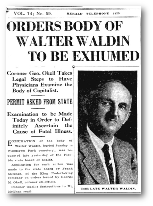
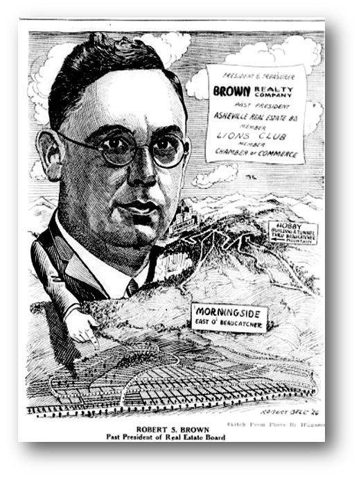
However, as Walter Waldin’s estate was being settled, events in Asheville were stewing which would soon seal the fate of “White Boulders”! “Tunnel Through Beaucatcher Mountain Is Being Advocated Here”, announced the February 1st, 1925 edition of the Asheville Sunday Citizen.[23] The article went on to report that the idea of building a tunnel through Beaucatcher was being proposed by Robert S. Brown, President of the Asheville Real Estate Board. Brown, who was a prime mover-shaker, was a muti-talented businessman, as well as being a professional engineer. He was the owner of Brown & Gibbs Engineering, Brown Realty, and Brown Development Company. Robert Brown proposed that the Tunnel was greatly needed to open the east side of Asheville for residential and commercial development. Then the only access to the east side of Beaucatcher required passing through the Beaucatcher Gap and negotiating a multi-switched backed road. Brown envisioned that the Tunnel would eventually connect with the Asheville-Black Mountain Highway (Highway 10), providing a scenic gateway into Asheville for those visitors approaching Asheville from the east. On the strength of the approval of the new Tunnel Project, in 1925, Brown purchased the former John Hildebrand farm on the east side of Beaucatcher and began developing it into a residential park named, “Morningside East ‘O Beaucatcher”. At the time, Brown was also beginning to develop “Oaklyn” on Fairview Road, which was the start of the modern-day Oakley community.
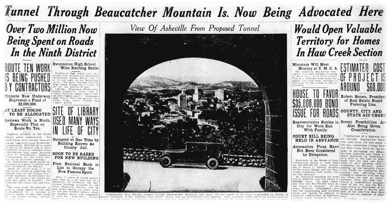
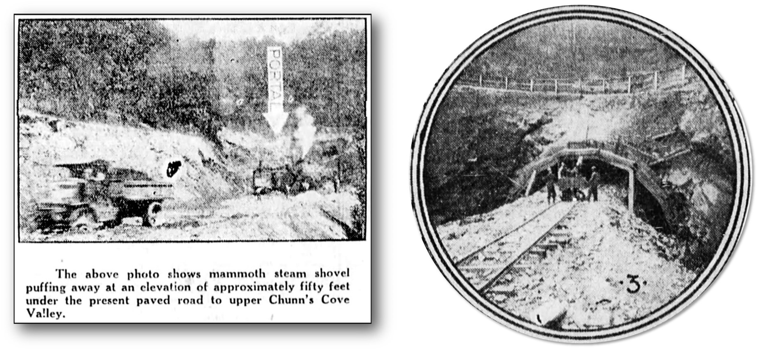
It would take another two years of planning, designing and political wranglings before any actual work on the Beaucatcher Tunnel was begun. The first excavations began in the Spring of 1927, and it would take an additional two years before the tunnel was opened for traffic in the summer of 1929. I had suspected that it was during this four-year period, 1925-1929, that the house at “White Boulders” was probably demolished. However, it turns out that the downfall of “White Boulders” was more drastic than just tearing down the house. Robert S. Brown had stated in 1925, when he made his proposal, that “No property would have to be purchased for the construction on the tunnel, as it would enter from a part of the present road and end on another part. The only thing that the public would have to secure would be a right of way to tunnel under property owned by Phillip S. Henry.”[24] Well, that wasn’t totally accurate. What he didn’t mention was that additional property on the east side of the tunnel at the east portal would have to be purchased for the construction of the proposed connector road (Tunnel Road) which was planned to connect the tunnel to the U.S. Highway 10 which ran along the Swannanoa River Road and ran east to Black Mountain and beyond. I know that Brown was aware of the proposed connector road, as in 1926, as plans were being drawn for the tunnel and before digging began, he purchased the nine acre “White Boulders” tract from Walter Waldin’s widow, Alice Waldin Scheuer, who had since remarried.[25] As the Waldin tract straddled the proposed east entrance to the tunnel, Brown knew that the land was not only needed to complete the connection of the tunnel to the highway, but that when all was completed he would possess a prime commercial property! As construction on the tunnel began a few months later, an advertisement style article, in the July 22, 1927 edition of the Asheville Citizen-Times, carried the headline: “Beaucatcher Tunnel- Vast Amount of Work Has Been Accomplished”.[26] The article/advertisement included two photographs that showed the work being done at the “approach cut” at the east portal, in preparation for the “Tunnel driving machinery” to soon begin the actual boring and construction of the tunnel. The caption on the top photo unknowingly revealed the final fate of the “White Boulders” property: “The above photo shows mammoth steam shovel puffing away at an elevation of at least fifty feet under the present paved road to upper Chunn’s Cove Valley.”[27] Except for a small portion along Chunns Cove Road, the “White Boulders” property was excavated and lowered fifty feet. All traces of the house, gardens, and fruit trees were utterly destroyed. A later similar article, in December 1927[28], also with a photo collage of the progress, shows an inset photo of the east portal after the first section of the tunnel had been completed. As a close-up it clearly shows how the ground at the portal had been excavated and lowered from the Chunns Cove Road above (shown bordered by a rail fence).
In an ironic twist of fate, Robert Brown defaulted on a Deed of Trust that he had taken out on the property in 1926 at the date of its purchase. Alice Waldin Scheuer bought back the 9-acre property at a Courthouse sale in July of 1931[29], and held on to it until selling it in the 1940’s at an increased value. Today, Robert Brown’s vision has come to fruition, as the former “White Boulders property, which straddles Tunnel Road, is now fully occupied by commercial/retail businesses. Who would have thought that a small non-descript and little noticed, piece of white granite, incised with the words “White Boulders” would have revealed so much of Asheville’s architectural history and development?
Photo & Image Credits: (Note: All cropping and captions by author)
“White Boulders” photo- Taken by Richard E. Howell, Asheville, NC.
Zealandia, c. 1890 photo- Marriott Canby Morris, 1863-1948, photographer. “Mr. Brown’s house. Zealandia, on Beaucatcher Mt. Mr. Brown on porch.” [Asheville, NC], March 21, 1890. Courtesy: Library Company of Philadelphia, Print Department, Marriott C. Morris Collection [P.9895.1597].
1891 Bird’s-Eye View of Asheville- Ruger & Stoner, and Burleigh Litho. bird’s-eye view of the city of Asheville, North Carolina. [Madison, Wis, 1891] Map. https://www.loc.gov/item/75694894/.
Zealandia, c. 1947 Photo- Image # A576-8, Buncombe County Special Collections, Pack Memorial Library, Asheville, NC.
Photo of Western Portal of Beaucatcher Tunnel, c. 1930’s- Image #B808-5, Buncombe County Special Collections, Pack Memorial Library, Asheville, NC.
Photo of Poplar Street & Western Portal of Tunnel- Image# B807-4, Buncombe County Special Collections, Pack Memorial Library, Asheville, NC.
Walter Waldin- “DEATH CALLS MIAMI CITIZEN”, The Miami News, Miami, FL, January 19, 1924, page 3.- newspapers.com
Overlay of Waldin Property on GIS- Bottom image from Buncombe County GIS, top image is deed sketch by Dale W. Slusser.
“Residence of P. S. Henry” siteplan- Sketch by Richard Sharp Smith, Image#RS0331.1, Asheville Art Museum – Richard Sharp Smith Collection- Image accessed through Buncombe County Special Collections, Pack Memorial Library, Asheville, NC.
Herbert Pelton Photo of Zealandia- Image G967-11, Buncombe County Special Collections, Pack Memorial Library, Asheville, NC.
“ORDERS BODY OF WALTER WALDIN TO BE EXHUMED”– Cropped from article, The Miami Herald (Miami, Florida), January 23, 1924, page 1. – newspapers.com
“Tunnel Through Beaucatcher Is Now Being Advocated Here”- The Sunday Citizen, Asheville, NC February 1, 1925, page 19. – newspapers.com
Robert Brown Sketch- “Folks You Should Know”- Asheville Citizen-Times, July 16, 1926, page 13. – newspapers.com
Photo of Steam Shovels Excavating East Portal of Tunnel Beaucatcher Tunnel- “Vast Amount of Work Has Been Accomplished”- Asheville Citizen-Times, July 22, 1927, page 9.- newspapers.com
Inset Photo of Work on East Portal at Tunnel- Asheville Citizen-Times, December 4, 1927, page 13.- newspapers.com
[1] J. Evans Brown’s bio information from: “Mr. John Evans Brown”, The Cyclopedia of New Zealand [Canterbury Provincial District], The Cyclopedia Company, Limited, 1903, Christchurch, NZ. http://www.nzetc.org/tm/scholarly/tei-Cyc03Cycl-t1-body1-d3-d6-d27.html
[2] “Death of J. Evans Brown”, Asheville Weekly Citizen, July 12, 1895, page 1.
[3] Asheville Citizen-Times, August 4, 1889, page 1.
[4] “Death of J. Evans Brown”, Asheville Weekly Citizen, July 12, 1895, page 1.
[5] 01/26/1901 Jane Emily Brown to Caroline E. Revell BEAUCATCHER MOUNTAIN Db. 119 / 163.-Buncombe County Register of Deeds.
[6] “Zealandia”, National Register of Historic Places Nomination, Prepared by Susanne Brendel & Betty Betz, Robert Griffin, and Jerry L. Cross, January 12, 1977.-Item no. 8, page 1.-BN0021.pdf – NC.gov- https://files.nc.gov
[7] Asheville Citizen-Times, October 5, 1950, page 6.
[8] Asheville Citizen-Times, September 17, 1923, page 11.
[9] Asheville Citizen-Times, December 23, 1923, page 27.
[10] “DEATH CALLS MIAMI CITIZEN”, The Miami News, Miami, FL, January 19, 1924, page 3.
[11] Ibid.
[12] Grunwald, Michael. The Swamp: The Everglades, Florida, and the Politics of Paradise. United Kingdom, Simon & Schuster, 2007, page 138.
[13] Waldin, Walter. Truck Farming in the Everglades. United States, E. F. Harman & Company, 1910.
[14] 09/27/1921 (rec’d-01/21/1922) T. C. & Sudie Ottinger to Alice Waldin
[15] Asheville Citizen-Times, April 25, 1922, page 13.
[16] Asheville Citizen-Times, April 29, 1922, page 9.
[17] “DEATH CALLS MIAMI CITIZEN”, The Miami News, Miami, FL, January 19, 1924, page 3.
[18] “Waldin Poison Suspicions Bared By Son At Inquest”, The Miami News, Miami, FL, January 23, 1924, page 1.
[19] “WALDIN’S DEATH DUE TO HEART DILATION”, The Miami Herald, Miami, FL, January 25, 1924, page 7.
[20] “AUTOPSY PERFORMED IN THE WALDIN CASE”, The Miami Herald, Miami, FL, January 24, 1924, Page 3.
[21] “WALTER WALDIN WILL IS FILED FOR PROBATE”, The Miami Herald, Miami, FL, March 7, 1924, page 18.
[22] Ibid.
[23] Asheville Sunday Citizen, February 1, 1925, page 19.
[24] Asheville Sunday Citizen, February 1, 1925, page 29.
[25] 04/22/1926 (rec’d-05/04/1926) Alice Waldin Scheuer & husband, Albert Scheuer to Robert S. Brown 9 ACRES CHUNS COVE RD Db. 344/317.- Buncombe County Register of Deeds.
[26] Asheville Citizen-Times, July 22, 1927, page 9.
[27] Ibid.
[28] Asheville Citizen-Times, December 4, 1927, page 13.
[29] 07/10/1931 (rec’d-08/22/1931 -J. C. Dillard, TR to Alice Waldin & Albert Scheuer 9 ACRES CHUNS COVE RD Db.442/301.- Buncombe County Register of Deeds.